Darley geodata
Darley (Victoria) is a populated place; located in Australia in Australia/Melbourne (GMT+11) time zone. With population of 8,281 people, there are 789 cities with bigger population in this country. Compared to other cities in Australia, 84.1% of cities are located further ↑North; 70.4% of cities are located further →East and 73.2% of cities have lower elevation than Darley. Note1


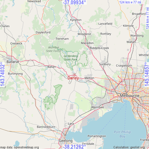
Darley GPS coordinates[2]
37° 39' 29.052" South, 144° 26' 36.384" East
| Map corner | latitude | longitude |
|---|---|---|
| Upper-left | -37.09934°, | 143.74032° |
| Center: | -37.65807°, | 144.44344° |
| Lower-right: | -38.21262°, | 145.14657° |
| Map W x H: | 123.8×123.8 km | = 76.9×76.9mi |
| max Lat: | -10.58257° ⇑84.1% North |
| Darley: | -37.65807° |
| min Lat: | ⇓15.9% South -43.31423° |
| min Long | Darley | max Long |
| 113.53327° | 144.44344° | 153.61246° |
| W 29.6%⇐ | ⇒70.4% E |
Elevation
Elevation of Darley is 118 m = 387 ft, and this is 4 m = 13 ft below average elevation for this country.
| Max E: |
1715 m = 5627 ft | 26.8% |
| Avg. | 122 m = 400 ft | |
| Darley | 118 m = 387 ft | |
Min E: |
-2 m = -7 ft | 73.2% |
See also: Australia elevation on elevation.city.
Geographical zone
Darley is located in South temperate zone (between Tropic of Capricorn and the Antarctic Circle). Distance of this Southern Tropic circle is 1581.3 km =982.6 mi to North.| Distance of | km | miles | from Darley |
|---|---|---|---|
| Equator | 4187.2 | 2601.8 | to North |
| Tropic Capricorn | 1581.3 | 982.6 | to North |
| Antarctic Circle | 3214 | 1997.1 | to South |
| South Pole | 5819.9 | 3616.3 | to South |


Nearby cities:
15 places around Darley: (largest is in red/bold)
• Bacchus Marsh
1.7 km =1.1 mi,  195°
195°
• Ballan
20 km =12.4 mi,  288°
288°
• Brookfield
11.3 km =7 mi,  114°
114°
• Bullengarook
16.1 km =10 mi,  12°
12°
• Eynesbury
19.6 km =12.2 mi,  143°
143°
• Gisborne South
19.3 km =12 mi,  47°
47°
• Greendale
16.9 km =10.5 mi,  310°
310°
• Hopetoun Park
6.4 km =4 mi,  127°
127°
• Kurunjang
13.7 km =8.5 mi,  98°
98°
• Maddingley
3.2 km =2 mi, 197°
• Melton
12.8 km =8 mi, 102°
• Melton South
12.8 km =8 mi,  115°
115°
• Melton West
11.3 km =7 mi, 101°
• Mount Cottrell
21.5 km =13.4 mi,  145°
145°
• Toolern Vale
15.2 km =9.4 mi,  64°
64°
Sources, notices
• [Note1] Compared only with cities in Australia existing in our database
• [Src1] Map data: © OpenStreetMap contributors (CC-BY-SA)
• [Src2] Other city data from geonames.org with taken over terms of usage.
• [Src3] Geographical zone / Annual Mean Temperature by Robert A. Rohde @ Wikipedia
