Bacchus Marsh geodata
Bacchus Marsh (Victoria) is a populated place; located in Australia in Australia/Melbourne (GMT+11) time zone. With population of 6,281 people, there are 1134 cities with bigger population in this country. Compared to other cities in Australia, 84.3% of cities are located further ↑North; 70.4% of cities are located further →East and 71.7% of cities have lower elevation than Bacchus Marsh. Note1


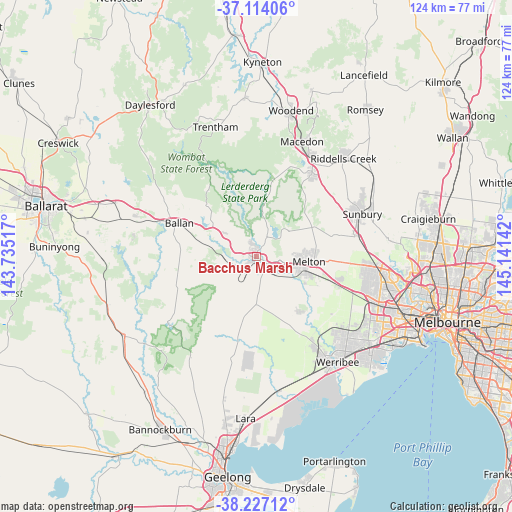
Bacchus Marsh GPS coordinates[2]
37° 40' 21.648" South, 144° 26' 17.844" East
| Map corner | latitude | longitude |
|---|---|---|
| Upper-left | -37.11406°, | 143.73517° |
| Center: | -37.67268°, | 144.43829° |
| Lower-right: | -38.22712°, | 145.14142° |
| Map W x H: | 123.8×123.8 km | = 76.9×76.9mi |
| max Lat: | -10.58257° ⇑84.3% North |
| Bacchus Marsh: | -37.67268° |
| min Lat: | ⇓15.7% South -43.31423° |
| min Long | Bacchus Marsh | max Long |
| 113.53327° | 144.43829° | 153.61246° |
| W 29.6%⇐ | ⇒70.4% E |
Elevation
Elevation of Bacchus Marsh is 111 m = 364 ft, and this is 11 m = 36 ft below average elevation for this country.
| Max E: |
1715 m = 5627 ft | 28.3% |
| Avg. | 122 m = 400 ft | |
| Bacchus Marsh | 111 m = 364 ft | |
Min E: |
-2 m = -7 ft | 71.7% |
See also: Australia elevation on elevation.city.
Geographical zone
Bacchus Marsh is located in South temperate zone (between Tropic of Capricorn and the Antarctic Circle). Distance of this Southern Tropic circle is 1582.9 km =983.6 mi to North.| Distance of | km | miles | from Bacchus Marsh |
|---|---|---|---|
| Equator | 4188.8 | 2602.8 | to North |
| Tropic Capricorn | 1582.9 | 983.6 | to North |
| Antarctic Circle | 3212.4 | 1996.1 | to South |
| South Pole | 5818.3 | 3615.3 | to South |


Nearby cities:
15 places around Bacchus Marsh: (largest is in red/bold)
• Ballan
20.1 km =12.5 mi,  293°
293°
• Brookfield
11.2 km =7 mi,  106°
106°
• Bullengarook
17.8 km =11.1 mi,  12°
12°
• Darley
1.7 km =1.1 mi,  15°
15°
• Eynesbury
18.6 km =11.6 mi,  139°
139°
• Gisborne South
20.7 km =12.9 mi,  45°
45°
• Greendale
17.6 km =10.9 mi,  315°
315°
• Hopetoun Park
6 km =3.7 mi, 112°
• Kurunjang
14 km =8.7 mi,  91°
91°
• Maddingley
1.5 km =0.9 mi,  200°
200°
• Melton
13 km =8.1 mi,  95°
95°
• Melton South
12.6 km =7.8 mi, 107°
• Melton West
11.5 km =7.1 mi, 93°
• Mount Cottrell
20.5 km =12.7 mi, 141°
• Toolern Vale
16.4 km =10.2 mi,  60°
60°
Sources, notices
• [Note1] Compared only with cities in Australia existing in our database
• [Src1] Map data: © OpenStreetMap contributors (CC-BY-SA)
• [Src2] Other city data from geonames.org with taken over terms of usage.
• [Src3] Geographical zone / Annual Mean Temperature by Robert A. Rohde @ Wikipedia
