Brookfield geodata
Brookfield (Victoria) is a section of populated place; located in Australia in Australia/Melbourne (GMT+11) time zone. With population of 9,145 people, there are 685 cities with bigger population in this country. Compared to other cities in Australia, 84.9% of cities are located further ↑North; 70.1% of cities are located further →East and 73.7% of cities have lower elevation than Brookfield. Note1


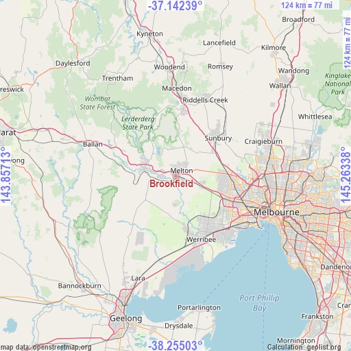
Brookfield GPS coordinates[2]
37° 42' 2.88" South, 144° 33' 36.9" East
| Map corner | latitude | longitude |
|---|---|---|
| Upper-left | -37.14239°, | 143.85713° |
| Center: | -37.7008°, | 144.56025° |
| Lower-right: | -38.25503°, | 145.26338° |
| Map W x H: | 123.7×123.7 km | = 76.9×76.9mi |
| max Lat: | -10.58257° ⇑84.9% North |
| Brookfield: | -37.7008° |
| min Lat: | ⇓15.1% South -43.31423° |
| min Long | Brookfield | max Long |
| 113.53327° | 144.56025° | 153.61246° |
| W 29.9%⇐ | ⇒70.1% E |
Elevation
Elevation of Brookfield is 121 m = 397 ft, and this is 1 m = 3 ft below average elevation for this country.
| Max E: |
1715 m = 5627 ft | 26.3% |
| Avg. | 122 m = 400 ft | |
| Brookfield | 121 m = 397 ft | |
Min E: |
-2 m = -7 ft | 73.7% |
See also: Australia elevation on elevation.city.
Geographical zone
Brookfield is located in South temperate zone (between Tropic of Capricorn and the Antarctic Circle). Distance of this Southern Tropic circle is 1586 km =985.5 mi to North.| Distance of | km | miles | from Brookfield |
|---|---|---|---|
| Equator | 4191.9 | 2604.7 | to North |
| Tropic Capricorn | 1586 | 985.5 | to North |
| Antarctic Circle | 3209.2 | 1994.1 | to South |
| South Pole | 5815.1 | 3613.3 | to South |


Nearby cities:
15 places around Brookfield: (largest is in red/bold)
• Bacchus Marsh
11.2 km =7 mi,  286°
286°
• Caroline Springs
16.1 km =10 mi,  106°
106°
• Darley
11.3 km =7 mi, 294°
• Eynesbury
11.1 km =6.9 mi,  173°
173°
• Hillside
16 km =9.9 mi,  85°
85°
• Hopetoun Park
5.3 km =3.3 mi,  279°
279°
• Kurunjang
4.3 km =2.7 mi,  49°
49°
• Maddingley
11.4 km =7.1 mi, 278°
• Melton
2.9 km =1.8 mi, 48°
• Melton South
1.5 km =0.9 mi,  120°
120°
• Melton West
2.6 km =1.6 mi,  16°
16°
• Mount Cottrell
13 km =8.1 mi, 171°
• Plumpton
11.6 km =7.2 mi,  82°
82°
• Rockbank
10.3 km =6.4 mi, 110°
• Toolern Vale
11.7 km =7.3 mi, 17°
Sources, notices
• [Note1] Compared only with cities in Australia existing in our database
• [Src1] Map data: © OpenStreetMap contributors (CC-BY-SA)
• [Src2] Other city data from geonames.org with taken over terms of usage.
• [Src3] Geographical zone / Annual Mean Temperature by Robert A. Rohde @ Wikipedia
