Gravelly Beach geodata
Gravelly Beach (Tasmania) is a populated place; located in Australia in Australia/Hobart (GMT+11) time zone. With population of 563 people, there are 4674 cities with bigger population in this country. Compared to other cities in Australia, 97.1% of cities are located further ↑North; 53.2% of cities are located further →East and 88.3% of cities have higher elevation than Gravelly Beach. Note1


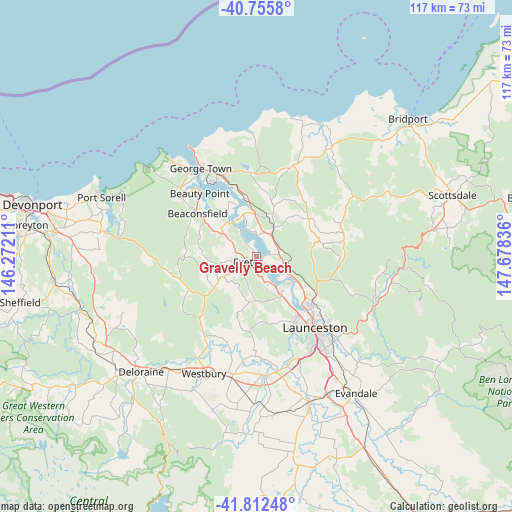
Gravelly Beach GPS coordinates[2]
41° 17' 10.608" South, 146° 58' 30.828" East
| Map corner | latitude | longitude |
|---|---|---|
| Upper-left | -40.7558°, | 146.27211° |
| Center: | -41.28628°, | 146.97523° |
| Lower-right: | -41.81248°, | 147.67836° |
| Map W x H: | 117.5×117.5 km | = 73×73mi |
| max Lat: | -10.58257° ⇑97.1% North |
| Gravelly Beach: | -41.28628° |
| min Lat: | ⇓2.9% South -43.31423° |
| min Long | Gravelly Beach | max Long |
| 113.53327° | 146.97523° | 153.61246° |
| W 46.8%⇐ | ⇒53.2% E |
Elevation
Elevation of Gravelly Beach is 10 m = 33 ft, and this is 112 m = 367 ft below average elevation for this country.
| Max E: |
1715 m = 5627 ft | 88.3% |
| Avg. | 122 m = 400 ft | |
| Gravelly Beach | 10 m = 33 ft | |
Min E: |
-2 m = -7 ft | 11.7% |
See also: Australia elevation on elevation.city.
Geographical zone
Gravelly Beach is located in South temperate zone (between Tropic of Capricorn and the Antarctic Circle). Distance of this Southern Tropic circle is 1984.7 km =1233.2 mi to North.| Distance of | km | miles | from Gravelly Beach |
|---|---|---|---|
| Equator | 4590.6 | 2852.5 | to North |
| Tropic Capricorn | 1984.7 | 1233.2 | to North |
| Antarctic Circle | 2810.6 | 1746.4 | to South |
| South Pole | 5416.5 | 3365.7 | to South |


Nearby cities:
15 places around Gravelly Beach: (largest is in red/bold)
• Beaconsfield
16.2 km =10.1 mi,  305°
305°
• Beauty Point
18.9 km =11.7 mi,  317°
317°
• Dilston
8.9 km =5.5 mi,  122°
122°
• Exeter
2.4 km =1.5 mi,  238°
238°
• Grindelwald
7.7 km =4.8 mi,  160°
160°
• Hillwood
4.7 km =2.9 mi,  9°
9°
• Invermay
19.9 km =12.4 mi,  138°
138°
• Legana
10.6 km =6.6 mi,  146°
146°
• Lilydale
20.6 km =12.8 mi,  78°
78°
• Mayfield
17.2 km =10.7 mi,  130°
130°
• Mowbray
19.5 km =12.1 mi, 131°
• Newnham
16.3 km =10.1 mi, 134°
• Riverside
16.3 km =10.1 mi, 157°
• Rocherlea
18.5 km =11.5 mi, 124°
• Trevallyn
20.5 km =12.7 mi, 148°
Sources, notices
• [Note1] Compared only with cities in Australia existing in our database
• [Src1] Map data: © OpenStreetMap contributors (CC-BY-SA)
• [Src2] Other city data from geonames.org with taken over terms of usage.
• [Src3] Geographical zone / Annual Mean Temperature by Robert A. Rohde @ Wikipedia
