Lethbridge geodata
Lethbridge (Victoria) is a populated place; located in Australia in Australia/Melbourne (GMT+11) time zone. With population of 994 people, there are 3829 cities with bigger population in this country. Compared to other cities in Australia, 91.4% of cities are located further ↑North; 72.2% of cities are located further →East and 79.2% of cities have lower elevation than Lethbridge. Note1


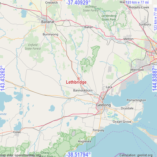
Lethbridge GPS coordinates[2]
37° 57' 56.556" South, 144° 8' 8.664" East
| Map corner | latitude | longitude |
|---|---|---|
| Upper-left | -37.40929°, | 143.43262° |
| Center: | -37.96571°, | 144.13574° |
| Lower-right: | -38.51794°, | 144.83887° |
| Map W x H: | 123.3×123.3 km | = 76.6×76.6mi |
| max Lat: | -10.58257° ⇑91.4% North |
| Lethbridge: | -37.96571° |
| min Lat: | ⇓8.6% South -43.31423° |
| min Long | Lethbridge | max Long |
| 113.53327° | 144.13574° | 153.61246° |
| W 27.8%⇐ | ⇒72.2% E |
Elevation
Elevation of Lethbridge is 169 m = 554 ft, and this is 47 m = 154 ft above average elevation for this country.
| Max E: |
1715 m = 5627 ft | 20.8% |
| Lethbridge | 169 m 554 ft | |
| Avg. | 122 m = 400 ft | |
Min E: |
-2 m = -7 ft | 79.2% |
See also: Australia elevation on elevation.city.
Geographical zone
Lethbridge is located in South temperate zone (between Tropic of Capricorn and the Antarctic Circle). Distance of this Southern Tropic circle is 1615.5 km =1003.8 mi to North.| Distance of | km | miles | from Lethbridge |
|---|---|---|---|
| Equator | 4221.4 | 2623.1 | to North |
| Tropic Capricorn | 1615.5 | 1003.8 | to North |
| Antarctic Circle | 3179.8 | 1975.8 | to South |
| South Pole | 5785.7 | 3595.1 | to South |


Nearby cities:
15 places around Lethbridge: (largest is in red/bold)
• Anakie
11.4 km =7.1 mi,  61°
61°
• Bannockburn
9.7 km =6 mi,  162°
162°
• Batesford
18.5 km =11.5 mi,  137°
137°
• Bell Park
23.8 km =14.8 mi,  131°
131°
• Bell Post Hill
21.6 km =13.4 mi, 131°
• Corio
25.3 km =15.7 mi,  121°
121°
• Hamlyn Heights
24.1 km =15 mi, 135°
• Herne Hill
25 km =15.5 mi, 138°
• Inverleigh
16.8 km =10.4 mi,  206°
206°
• Lara
24.6 km =15.3 mi,  105°
105°
• Lovely Banks
20.6 km =12.8 mi, 122°
• Meredith
14.3 km =8.9 mi,  339°
339°
• Norlane
24.4 km =15.2 mi, 128°
• North Geelong
24.7 km =15.3 mi, 130°
• Teesdale
10.6 km =6.6 mi,  224°
224°
Sources, notices
• [Note1] Compared only with cities in Australia existing in our database
• [Src1] Map data: © OpenStreetMap contributors (CC-BY-SA)
• [Src2] Other city data from geonames.org with taken over terms of usage.
• [Src3] Geographical zone / Annual Mean Temperature by Robert A. Rohde @ Wikipedia
