Meredith geodata
Meredith (Victoria) is a populated place; located in Australia in Australia/Melbourne (GMT+11) time zone. With population of 761 people, there are 4223 cities with bigger population in this country. Compared to other cities in Australia, 89.1% of cities are located further ↑North; 72.4% of cities are located further →East and 88.8% of cities have lower elevation than Meredith. Note1


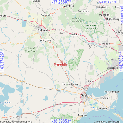
Meredith GPS coordinates[2]
37° 50' 43.404" South, 144° 4' 38.568" East
| Map corner | latitude | longitude |
|---|---|---|
| Upper-left | -37.28807°, | 143.37426° |
| Center: | -37.84539°, | 144.07738° |
| Lower-right: | -38.39853°, | 144.78051° |
| Map W x H: | 123.5×123.5 km | = 76.7×76.7mi |
| max Lat: | -10.58257° ⇑89.1% North |
| Meredith: | -37.84539° |
| min Lat: | ⇓10.9% South -43.31423° |
| min Long | Meredith | max Long |
| 113.53327° | 144.07738° | 153.61246° |
| W 27.6%⇐ | ⇒72.4% E |
Elevation
Elevation of Meredith is 338 m = 1109 ft, and this is 216 m = 709 ft above average elevation for this country.
| Max E: |
1715 m = 5627 ft | 11.2% |
| Meredith | 338 m 1109 ft | |
| Avg. | 122 m = 400 ft | |
Min E: |
-2 m = -7 ft | 88.8% |
See also: Australia elevation on elevation.city.
Geographical zone
Meredith is located in South temperate zone (between Tropic of Capricorn and the Antarctic Circle). Distance of this Southern Tropic circle is 1602.1 km =995.5 mi to North.| Distance of | km | miles | from Meredith |
|---|---|---|---|
| Equator | 4208 | 2614.7 | to North |
| Tropic Capricorn | 1602.1 | 995.5 | to North |
| Antarctic Circle | 3193.2 | 1984.2 | to South |
| South Pole | 5799 | 3603.3 | to South |


Nearby cities:
15 places around Meredith: (largest is in red/bold)
• Anakie
17.1 km =10.6 mi,  117°
117°
• Ballan
30.4 km =18.9 mi,  26°
26°
• Bannockburn
24 km =14.9 mi,  160°
160°
• Batesford
32.2 km =20 mi,  146°
146°
• Buninyong
27.6 km =17.1 mi,  321°
321°
• Dereel
27.5 km =17.1 mi,  276°
276°
• Enfield
28.1 km =17.5 mi,  297°
297°
• Gordon
29.4 km =18.3 mi,  5°
5°
• Inverleigh
28.6 km =17.8 mi,  184°
184°
• Lethbridge
14.3 km =8.9 mi, 159°
• Mount Clear
32.2 km =20 mi,  327°
327°
• Mount Egerton
23.7 km =14.7 mi,  4°
4°
• Mount Helen
30.1 km =18.7 mi, 324°
• Napoleons
29.2 km =18.1 mi,  312°
312°
• Teesdale
21 km =13 mi,  186°
186°
Sources, notices
• [Note1] Compared only with cities in Australia existing in our database
• [Src1] Map data: © OpenStreetMap contributors (CC-BY-SA)
• [Src2] Other city data from geonames.org with taken over terms of usage.
• [Src3] Geographical zone / Annual Mean Temperature by Robert A. Rohde @ Wikipedia
