Anakie geodata
Anakie (Victoria) is a populated place; located in Australia in Australia/Melbourne (GMT+11) time zone. With population of 666 people, there are 4391 cities with bigger population in this country. Compared to other cities in Australia, 90.8% of cities are located further ↑North; 71.9% of cities are located further →East and 78.5% of cities have lower elevation than Anakie. Note1


Anakie GPS coordinates[2]
37° 55' 0.012" South, 144° 15' 0" East
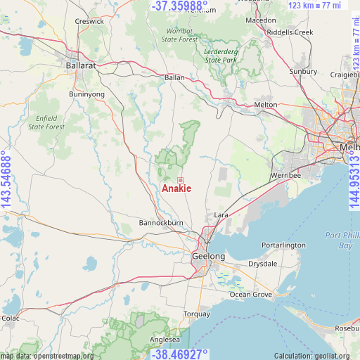
| Map corner | latitude | longitude |
|---|---|---|
| Upper-left | -37.35988°, | 143.54688° |
| Center: | -37.91667°, | 144.25° |
| Lower-right: | -38.46927°, | 144.95313° |
| Map W x H: | 123.4×123.4 km | = 76.7×76.7mi |
| max Lat: | -10.58257° ⇑90.8% North |
| Anakie: | -37.91667° |
| min Lat: | ⇓9.2% South -43.31423° |
| min Long | Anakie | max Long |
| 113.53327° | 144.25° | 153.61246° |
| W 28.1%⇐ | ⇒71.9% E |
Elevation
Elevation of Anakie is 162 m = 531 ft, and this is 40 m = 131 ft above average elevation for this country.
| Max E: |
1715 m = 5627 ft | 21.5% |
| Anakie | 162 m 531 ft | |
| Avg. | 122 m = 400 ft | |
Min E: |
-2 m = -7 ft | 78.5% |
See also: Australia elevation on elevation.city.
Geographical zone
Anakie is located in South temperate zone (between Tropic of Capricorn and the Antarctic Circle). Distance of this Southern Tropic circle is 1610 km =1000.4 mi to North.| Distance of | km | miles | from Anakie |
|---|---|---|---|
| Equator | 4215.9 | 2619.6 | to North |
| Tropic Capricorn | 1610 | 1000.4 | to North |
| Antarctic Circle | 3185.2 | 1979.2 | to South |
| South Pole | 5791.1 | 3598.4 | to South |


Nearby cities:
15 places around Anakie: (largest is in red/bold)
• Bannockburn
16.3 km =10.1 mi,  205°
205°
• Batesford
19.2 km =11.9 mi,  172°
172°
• Bell Park
22.6 km =14 mi,  159°
159°
• Bell Post Hill
20.8 km =12.9 mi, 162°
• Corio
21.9 km =13.6 mi,  147°
147°
• Hamlyn Heights
23.7 km =14.7 mi, 163°
• Lara
18.2 km =11.3 mi,  131°
131°
• Lethbridge
11.4 km =7.1 mi,  241°
241°
• Little River
22.6 km =14 mi,  104°
104°
• Lovely Banks
18.2 km =11.3 mi, 156°
• Meredith
17.1 km =10.6 mi,  297°
297°
• Norlane
22.5 km =14 mi, 156°
• North Geelong
23.2 km =14.4 mi, 157°
• Rippleside
25 km =15.5 mi, 158°
• Teesdale
21.8 km =13.5 mi,  233°
233°
Sources, notices
• [Note1] Compared only with cities in Australia existing in our database
• [Src1] Map data: © OpenStreetMap contributors (CC-BY-SA)
• [Src2] Other city data from geonames.org with taken over terms of usage.
• [Src3] Geographical zone / Annual Mean Temperature by Robert A. Rohde @ Wikipedia
