Kilkivan geodata
Kilkivan (Queensland) is a populated place; located in Australia in Australia/Brisbane (GMT+10) time zone. With population of 733 people, there are 4274 cities with bigger population in this country. Compared to other cities in Australia, 88.6% of cities are located further ↓South; 83.4% of cities are located further ←West and 78% of cities have lower elevation than Kilkivan. Note1


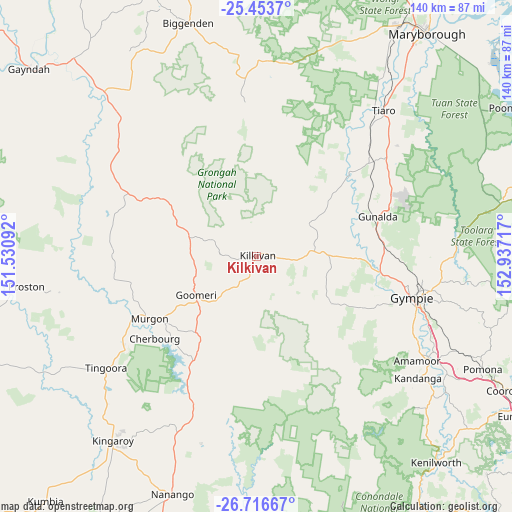
Kilkivan GPS coordinates[2]
26° 5' 12.804" South, 152° 14' 2.544" East
| Map corner | latitude | longitude |
|---|---|---|
| Upper-left | -25.4537°, | 151.53092° |
| Center: | -26.08689°, | 152.23404° |
| Lower-right: | -26.71667°, | 152.93717° |
| Map W x H: | 140.4×140.4 km | = 87.2×87.2mi |
| max Lat: | -10.58257° ⇑11.4% North |
| Kilkivan: | -26.08689° |
| min Lat: | ⇓88.6% South -43.31423° |
| min Long | Kilkivan | max Long |
| 113.53327° | 152.23404° | 153.61246° |
| W 83.4%⇐ | ⇒16.6% E |
Elevation
Elevation of Kilkivan is 156 m = 512 ft, and this is 34 m = 112 ft above average elevation for this country.
| Max E: |
1715 m = 5627 ft | 22% |
| Kilkivan | 156 m 512 ft | |
| Avg. | 122 m = 400 ft | |
Min E: |
-2 m = -7 ft | 78% |
See also: Australia elevation on elevation.city.
Geographical zone
Kilkivan is located in South temperate zone (between Tropic of Capricorn and the Antarctic Circle). Distance of this Southern Tropic circle is 294.7 km =183.1 mi to North.| Distance of | km | miles | from Kilkivan |
|---|---|---|---|
| Equator | 2900.6 | 1802.3 | to North |
| Tropic Capricorn | 294.7 | 183.1 | to North |
| Antarctic Circle | 4500.6 | 2796.5 | to South |
| South Pole | 7106.5 | 4415.8 | to South |


Nearby cities:
15 places around Kilkivan: (largest is in red/bold)
• Araluen
42.5 km =26.4 mi,  100°
100°
• Chatsworth
38.6 km =24 mi, 99°
• Cherbourg
36.2 km =22.5 mi,  230°
230°
• Curra
35 km =21.7 mi,  86°
86°
• Goomeri
19.7 km =12.2 mi,  236°
236°
• Gympie
44.5 km =27.7 mi, 104°
• Jones Hill
46.2 km =28.7 mi,  110°
110°
• Murgon
34 km =21.1 mi, 239°
• Pie Creek
40.5 km =25.2 mi, 113°
• Southside
43.4 km =27 mi, 108°
• Tamaree
43.2 km =26.8 mi, 97°
• The Palms
37.5 km =23.3 mi, 110°
• Veteran
46.2 km =28.7 mi, 99°
• Widgee
24.4 km =15.2 mi,  126°
126°
• Wondai
44.3 km =27.5 mi, 234°
Sources, notices
• [Note1] Compared only with cities in Australia existing in our database
• [Src1] Map data: © OpenStreetMap contributors (CC-BY-SA)
• [Src2] Other city data from geonames.org with taken over terms of usage.
• [Src3] Geographical zone / Annual Mean Temperature by Robert A. Rohde @ Wikipedia
