Murgon geodata
Murgon (Queensland) is a populated place; located in Australia in Australia/Brisbane (GMT+10) time zone. With population of 2,386 people, there are 2636 cities with bigger population in this country. Compared to other cities in Australia, 88.3% of cities are located further ↓South; 82.1% of cities are located further ←West and 88.1% of cities have lower elevation than Murgon. Note1


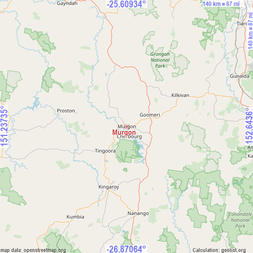
Murgon GPS coordinates[2]
26° 14' 30.12" South, 151° 56' 25.692" East
| Map corner | latitude | longitude |
|---|---|---|
| Upper-left | -25.60934°, | 151.23735° |
| Center: | -26.2417°, | 151.94047° |
| Lower-right: | -26.87064°, | 152.6436° |
| Map W x H: | 140.2×140.2 km | = 87.1×87.1mi |
| max Lat: | -10.58257° ⇑11.7% North |
| Murgon: | -26.2417° |
| min Lat: | ⇓88.3% South -43.31423° |
| min Long | Murgon | max Long |
| 113.53327° | 151.94047° | 153.61246° |
| W 82.1%⇐ | ⇒17.9% E |
Elevation
Elevation of Murgon is 317 m = 1040 ft, and this is 195 m = 640 ft above average elevation for this country.
| Max E: |
1715 m = 5627 ft | 11.9% |
| Murgon | 317 m 1040 ft | |
| Avg. | 122 m = 400 ft | |
Min E: |
-2 m = -7 ft | 88.1% |
See also: Australia elevation on elevation.city.
Geographical zone
Murgon is located in South temperate zone (between Tropic of Capricorn and the Antarctic Circle). Distance of this Southern Tropic circle is 311.9 km =193.8 mi to North.| Distance of | km | miles | from Murgon |
|---|---|---|---|
| Equator | 2917.8 | 1813 | to North |
| Tropic Capricorn | 311.9 | 193.8 | to North |
| Antarctic Circle | 4483.4 | 2785.9 | to South |
| South Pole | 7089.3 | 4405.1 | to South |


Nearby cities:
15 places around Murgon: (largest is in red/bold)
• Booie
32.8 km =20.4 mi,  179°
179°
• Cherbourg
5.7 km =3.5 mi,  168°
168°
• Curra
67 km =41.6 mi,  73°
73°
• Goomeri
14.3 km =8.9 mi,  63°
63°
• Kilkivan
34 km =21.1 mi, 59°
• Kingaroy
34.7 km =21.6 mi,  197°
197°
• Nanango
48.2 km =30 mi, 172°
• Pie Creek
66.6 km =41.4 mi,  88°
88°
• South Nanango
56.6 km =35.2 mi, 177°
• Taabinga
39.5 km =24.5 mi, 195°
• The Palms
64.6 km =40.1 mi, 86°
• Wattle Camp
24.1 km =15 mi, 174°
• Widgee
49 km =30.4 mi, 86°
• Wondai
10.8 km =6.7 mi,  218°
218°
• Yarraman
66.8 km =41.5 mi, 176°
Sources, notices
• [Note1] Compared only with cities in Australia existing in our database
• [Src1] Map data: © OpenStreetMap contributors (CC-BY-SA)
• [Src2] Other city data from geonames.org with taken over terms of usage.
• [Src3] Geographical zone / Annual Mean Temperature by Robert A. Rohde @ Wikipedia
