Gleneagle geodata
Gleneagle (Queensland) is a populated place; located in Australia in Australia/Brisbane (GMT+10) time zone. With population of 1,870 people, there are 2993 cities with bigger population in this country. Compared to other cities in Australia, 76.6% of cities are located further ↓South; 90.5% of cities are located further ←West and 56.9% of cities have lower elevation than Gleneagle. Note1


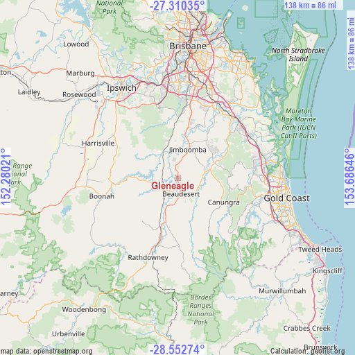
Gleneagle GPS coordinates[2]
27° 55' 59.988" South, 152° 58' 59.988" East
| Map corner | latitude | longitude |
|---|---|---|
| Upper-left | -27.31035°, | 152.28021° |
| Center: | -27.93333°, | 152.98333° |
| Lower-right: | -28.55274°, | 153.68646° |
| Map W x H: | 138.1×138.1 km | = 85.8×85.8mi |
| max Lat: | -10.58257° ⇑23.4% North |
| Gleneagle: | -27.93333° |
| min Lat: | ⇓76.6% South -43.31423° |
| min Long | Gleneagle | max Long |
| 113.53327° | 152.98333° | 153.61246° |
| W 90.5%⇐ | ⇒9.5% E |
Elevation
Elevation of Gleneagle is 57 m = 187 ft, and this is 65 m = 213 ft below average elevation for this country.
| Max E: |
1715 m = 5627 ft | 43.1% |
| Avg. | 122 m = 400 ft | |
| Gleneagle | 57 m = 187 ft | |
Min E: |
-2 m = -7 ft | 56.9% |
See also: Australia elevation on elevation.city.
Geographical zone
Gleneagle is located in South temperate zone (between Tropic of Capricorn and the Antarctic Circle). Distance of this Southern Tropic circle is 500 km =310.7 mi to North.| Distance of | km | miles | from Gleneagle |
|---|---|---|---|
| Equator | 3105.9 | 1929.9 | to North |
| Tropic Capricorn | 500 | 310.7 | to North |
| Antarctic Circle | 4295.3 | 2669 | to South |
| South Pole | 6901.2 | 4288.2 | to South |


Nearby cities:
15 places around Gleneagle: (largest is in red/bold)
• Beaudesert
6.1 km =3.8 mi,  167°
167°
• Boyland
14.9 km =9.3 mi,  97°
97°
• Canungra
20.1 km =12.5 mi,  117°
117°
• Cedar Grove
7.4 km =4.6 mi,  0°
0°
• Cedar Vale
6.6 km =4.1 mi,  42°
42°
• Jimboomba
12.2 km =7.6 mi,  20°
20°
• Mundoolun
9.4 km =5.8 mi,  66°
66°
• Munruben
21.3 km =13.2 mi,  12°
12°
• New Beith
18.3 km =11.4 mi,  327°
327°
• North Maclean
18.7 km =11.6 mi, 10°
• South Maclean
16 km =9.9 mi, 11°
• Stockleigh
20.3 km =12.6 mi, 23°
• Tamborine
15.8 km =9.8 mi, 69°
• Woodhill
4.1 km =2.5 mi,  336°
336°
• Yarrabilba
18.7 km =11.6 mi, 42°
Sources, notices
• [Note1] Compared only with cities in Australia existing in our database
• [Src1] Map data: © OpenStreetMap contributors (CC-BY-SA)
• [Src2] Other city data from geonames.org with taken over terms of usage.
• [Src3] Geographical zone / Annual Mean Temperature by Robert A. Rohde @ Wikipedia
