Cedar Grove geodata
Cedar Grove (Queensland) is a section of populated place; located in Australia in Australia/Brisbane (GMT+10) time zone. With population of 2,018 people, there are 2899 cities with bigger population in this country. Compared to other cities in Australia, 76.9% of cities are located further ↓South; 90.5% of cities are located further ←West and 55.8% of cities have lower elevation than Cedar Grove. Note1


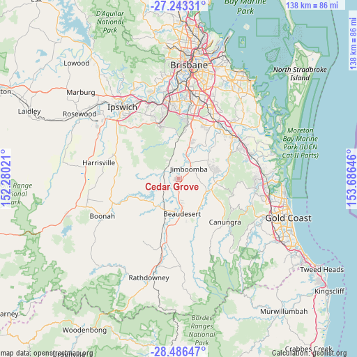
Cedar Grove GPS coordinates[2]
27° 52' 0.012" South, 152° 58' 59.988" East
| Map corner | latitude | longitude |
|---|---|---|
| Upper-left | -27.24331°, | 152.28021° |
| Center: | -27.86667°, | 152.98333° |
| Lower-right: | -28.48647°, | 153.68646° |
| Map W x H: | 138.2×138.2 km | = 85.9×85.9mi |
| max Lat: | -10.58257° ⇑23.1% North |
| Cedar Grove: | -27.86667° |
| min Lat: | ⇓76.9% South -43.31423° |
| min Long | Cedar Grove | max Long |
| 113.53327° | 152.98333° | 153.61246° |
| W 90.5%⇐ | ⇒9.5% E |
Elevation
Elevation of Cedar Grove is 55 m = 180 ft, and this is 67 m = 220 ft below average elevation for this country.
| Max E: |
1715 m = 5627 ft | 44.2% |
| Avg. | 122 m = 400 ft | |
| Cedar Grove | 55 m = 180 ft | |
Min E: |
-2 m = -7 ft | 55.8% |
See also: Australia elevation on elevation.city.
Geographical zone
Cedar Grove is located in South temperate zone (between Tropic of Capricorn and the Antarctic Circle). Distance of this Southern Tropic circle is 492.6 km =306.1 mi to North.| Distance of | km | miles | from Cedar Grove |
|---|---|---|---|
| Equator | 3098.5 | 1925.3 | to North |
| Tropic Capricorn | 492.6 | 306.1 | to North |
| Antarctic Circle | 4302.7 | 2673.6 | to South |
| South Pole | 6908.6 | 4292.8 | to South |


Nearby cities:
15 places around Cedar Grove: (largest is in red/bold)
• Beaudesert
13.4 km =8.3 mi,  174°
174°
• Cedar Vale
5.1 km =3.2 mi,  119°
119°
• Chambers Flat
16.1 km =10 mi,  35°
35°
• Gleneagle
7.4 km =4.6 mi,  180°
180°
• Jimboomba
5.9 km =3.7 mi,  47°
47°
• Mundoolun
9.4 km =5.8 mi,  112°
112°
• Munruben
14.2 km =8.8 mi,  19°
19°
• New Beith
12.7 km =7.9 mi,  309°
309°
• North Maclean
11.5 km =7.1 mi, 16°
• Park Ridge South
16.3 km =10.1 mi, 17°
• South Maclean
8.9 km =5.5 mi, 21°
• Stockleigh
13.8 km =8.6 mi, 36°
• Tamborine
14.9 km =9.3 mi,  97°
97°
• Woodhill
4.1 km =2.5 mi,  203°
203°
• Yarrabilba
14.2 km =8.8 mi,  62°
62°
Sources, notices
• [Note1] Compared only with cities in Australia existing in our database
• [Src1] Map data: © OpenStreetMap contributors (CC-BY-SA)
• [Src2] Other city data from geonames.org with taken over terms of usage.
• [Src3] Geographical zone / Annual Mean Temperature by Robert A. Rohde @ Wikipedia
