Chiltern geodata
Chiltern (Victoria) is a populated place; located in Australia in Australia/Melbourne (GMT+11) time zone. With population of 1,561 people, there are 3225 cities with bigger population in this country. Compared to other cities in Australia, 79% of cities are located further ↑North; 55.1% of cities are located further →East and 82.2% of cities have lower elevation than Chiltern. Note1


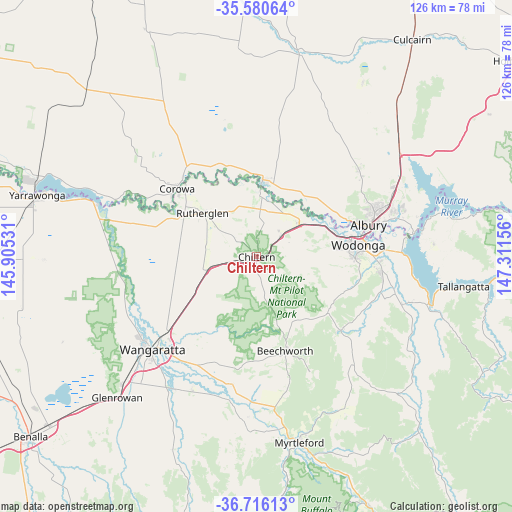
Chiltern GPS coordinates[2]
36° 9' 1.584" South, 146° 36' 30.348" East
| Map corner | latitude | longitude |
|---|---|---|
| Upper-left | -35.58064°, | 145.90531° |
| Center: | -36.15044°, | 146.60843° |
| Lower-right: | -36.71613°, | 147.31156° |
| Map W x H: | 126.3×126.3 km | = 78.5×78.5mi |
| max Lat: | -10.58257° ⇑79% North |
| Chiltern: | -36.15044° |
| min Lat: | ⇓21% South -43.31423° |
| min Long | Chiltern | max Long |
| 113.53327° | 146.60843° | 153.61246° |
| W 44.9%⇐ | ⇒55.1% E |
Elevation
Elevation of Chiltern is 207 m = 679 ft, and this is 85 m = 279 ft above average elevation for this country.
| Max E: |
1715 m = 5627 ft | 17.8% |
| Chiltern | 207 m 679 ft | |
| Avg. | 122 m = 400 ft | |
Min E: |
-2 m = -7 ft | 82.2% |
See also: Australia elevation on elevation.city.
Geographical zone
Chiltern is located in South temperate zone (between Tropic of Capricorn and the Antarctic Circle). Distance of this Southern Tropic circle is 1413.6 km =878.4 mi to North.| Distance of | km | miles | from Chiltern |
|---|---|---|---|
| Equator | 4019.6 | 2497.7 | to North |
| Tropic Capricorn | 1413.6 | 878.4 | to North |
| Antarctic Circle | 3381.6 | 2101.2 | to South |
| South Pole | 5987.5 | 3720.5 | to South |


Nearby cities:
15 places around Chiltern: (largest is in red/bold)
• Albury
29.6 km =18.4 mi,  73°
73°
• Bandiana
28.5 km =17.7 mi,  89°
89°
• Barnawartha
8 km =5 mi,  49°
49°
• Beechworth
24.1 km =15 mi,  163°
163°
• Corowa
26.3 km =16.3 mi,  310°
310°
• Glenroy
29.3 km =18.2 mi, 67°
• Howlong
18.9 km =11.7 mi,  6°
6°
• Leneva
27.2 km =16.9 mi,  105°
105°
• Rutherglen
16.9 km =10.5 mi, 309°
• South Albury
27.9 km =17.3 mi,  75°
75°
• Wahgunyah
24.5 km =15.2 mi, 309°
• West Albury
26.7 km =16.6 mi, 72°
• West Wodonga
22.1 km =13.7 mi, 82°
• Wodonga
25.3 km =15.7 mi, 82°
• Yackandandah
27.6 km =17.1 mi,  131°
131°
Sources, notices
• [Note1] Compared only with cities in Australia existing in our database
• [Src1] Map data: © OpenStreetMap contributors (CC-BY-SA)
• [Src2] Other city data from geonames.org with taken over terms of usage.
• [Src3] Geographical zone / Annual Mean Temperature by Robert A. Rohde @ Wikipedia
