Barnawartha geodata
Barnawartha (Victoria) is a populated place; located in Australia in Australia/Melbourne (GMT+11) time zone. With population of 871 people, there are 4018 cities with bigger population in this country. Compared to other cities in Australia, 78.8% of cities are located further ↑North; 54.9% of cities are located further →East and 79.6% of cities have lower elevation than Barnawartha. Note1


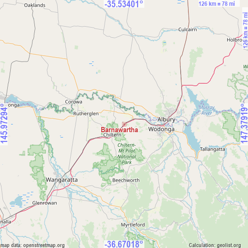
Barnawartha GPS coordinates[2]
36° 6' 14.94" South, 146° 40' 33.816" East
| Map corner | latitude | longitude |
|---|---|---|
| Upper-left | -35.53401°, | 145.97294° |
| Center: | -36.10415°, | 146.67606° |
| Lower-right: | -36.67018°, | 147.37919° |
| Map W x H: | 126.3×126.3 km | = 78.5×78.5mi |
| max Lat: | -10.58257° ⇑78.8% North |
| Barnawartha: | -36.10415° |
| min Lat: | ⇓21.2% South -43.31423° |
| min Long | Barnawartha | max Long |
| 113.53327° | 146.67606° | 153.61246° |
| W 45.1%⇐ | ⇒54.9% E |
Elevation
Elevation of Barnawartha is 176 m = 577 ft, and this is 54 m = 177 ft above average elevation for this country.
| Max E: |
1715 m = 5627 ft | 20.4% |
| Barnawartha | 176 m 577 ft | |
| Avg. | 122 m = 400 ft | |
Min E: |
-2 m = -7 ft | 79.6% |
See also: Australia elevation on elevation.city.
Geographical zone
Barnawartha is located in South temperate zone (between Tropic of Capricorn and the Antarctic Circle). Distance of this Southern Tropic circle is 1408.5 km =875.2 mi to North.| Distance of | km | miles | from Barnawartha |
|---|---|---|---|
| Equator | 4014.4 | 2494.4 | to North |
| Tropic Capricorn | 1408.5 | 875.2 | to North |
| Antarctic Circle | 3386.8 | 2104.5 | to South |
| South Pole | 5992.7 | 3723.7 | to South |


Nearby cities:
15 places around Barnawartha: (largest is in red/bold)
• Albury
22.5 km =14 mi,  81°
81°
• Bandiana
23 km =14.3 mi,  102°
102°
• Chiltern
8 km =5 mi,  229°
229°
• East Albury
22.9 km =14.2 mi, 83°
• Glenroy
21.9 km =13.6 mi,  74°
74°
• Hamilton Valley
22.9 km =14.2 mi, 71°
• Howlong
14.1 km =8.8 mi,  343°
343°
• Lavington
24.7 km =15.3 mi, 73°
• Leneva
23.7 km =14.7 mi,  121°
121°
• North Albury
23.4 km =14.5 mi, 77°
• Rutherglen
20 km =12.4 mi,  286°
286°
• South Albury
21 km =13 mi, 84°
• West Albury
19.6 km =12.2 mi, 82°
• West Wodonga
15.9 km =9.9 mi, 97°
• Wodonga
19.1 km =11.9 mi, 95°
Sources, notices
• [Note1] Compared only with cities in Australia existing in our database
• [Src1] Map data: © OpenStreetMap contributors (CC-BY-SA)
• [Src2] Other city data from geonames.org with taken over terms of usage.
• [Src3] Geographical zone / Annual Mean Temperature by Robert A. Rohde @ Wikipedia
