Holbrook geodata
Holbrook (New South Wales) is a populated place; located in Australia in Australia/Sydney (GMT+11) time zone. With population of 1,688 people, there are 3110 cities with bigger population in this country. Compared to other cities in Australia, 77.7% of cities are located further ↑North; 51% of cities are located further →East and 86.1% of cities have lower elevation than Holbrook. Note1


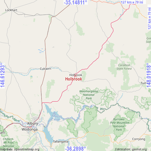
Holbrook GPS coordinates[2]
35° 43' 15.6" South, 147° 18' 57.78" East
| Map corner | latitude | longitude |
|---|---|---|
| Upper-left | -35.14811°, | 146.61293° |
| Center: | -35.721°, | 147.31605° |
| Lower-right: | -36.2898°, | 148.01918° |
| Map W x H: | 126.9×126.9 km | = 78.9×78.9mi |
| max Lat: | -10.58257° ⇑77.7% North |
| Holbrook: | -35.721° |
| min Lat: | ⇓22.3% South -43.31423° |
| min Long | Holbrook | max Long |
| 113.53327° | 147.31605° | 153.61246° |
| W 49%⇐ | ⇒51% E |
Elevation
Elevation of Holbrook is 267 m = 876 ft, and this is 145 m = 476 ft above average elevation for this country.
| Max E: |
1715 m = 5627 ft | 13.9% |
| Holbrook | 267 m 876 ft | |
| Avg. | 122 m = 400 ft | |
Min E: |
-2 m = -7 ft | 86.1% |
See also: Australia elevation on elevation.city.
Geographical zone
Holbrook is located in South temperate zone (between Tropic of Capricorn and the Antarctic Circle). Distance of this Southern Tropic circle is 1365.9 km =848.7 mi to North.| Distance of | km | miles | from Holbrook |
|---|---|---|---|
| Equator | 3971.8 | 2468 | to North |
| Tropic Capricorn | 1365.9 | 848.7 | to North |
| Antarctic Circle | 3429.4 | 2130.9 | to South |
| South Pole | 6035.3 | 3750.2 | to South |


Nearby cities:
15 places around Holbrook: (largest is in red/bold)
• Albury
52.9 km =32.9 mi,  221°
221°
• Culcairn
25.8 km =16 mi,  283°
283°
• East Albury
53.1 km =33 mi, 220°
• Gerogery
31.8 km =19.8 mi,  246°
246°
• Glenroy
51.7 km =32.1 mi, 224°
• Hamilton Valley
50.3 km =31.3 mi,  225°
225°
• Henty
33.8 km =21 mi,  311°
311°
• Jindera
46.5 km =28.9 mi,  236°
236°
• Lavington
49.1 km =30.5 mi, 223°
• North Albury
51.1 km =31.8 mi, 222°
• Springdale Heights
47.8 km =29.7 mi, 223°
• Table Top
39.5 km =24.5 mi, 226°
• The Rock
53.1 km =33 mi,  339°
339°
• Thurgoona
45.4 km =28.2 mi, 219°
• Walla Walla
37.7 km =23.4 mi,  263°
263°
Sources, notices
• [Note1] Compared only with cities in Australia existing in our database
• [Src1] Map data: © OpenStreetMap contributors (CC-BY-SA)
• [Src2] Other city data from geonames.org with taken over terms of usage.
• [Src3] Geographical zone / Annual Mean Temperature by Robert A. Rohde @ Wikipedia
