Gembrook geodata
Gembrook (Victoria) is a section of populated place; located in Australia in Australia/Melbourne (GMT+11) time zone. With population of 2,327 people, there are 2674 cities with bigger population in this country. Compared to other cities in Australia, 91.3% of cities are located further ↑North; 59.4% of cities are located further →East and 88.3% of cities have lower elevation than Gembrook. Note1


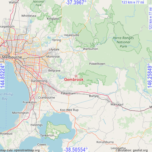
Gembrook GPS coordinates[2]
37° 57' 11.556" South, 145° 33' 19.296" East
| Map corner | latitude | longitude |
|---|---|---|
| Upper-left | -37.3967°, | 144.85224° |
| Center: | -37.95321°, | 145.55536° |
| Lower-right: | -38.50554°, | 146.25849° |
| Map W x H: | 123.3×123.3 km | = 76.6×76.6mi |
| max Lat: | -10.58257° ⇑91.3% North |
| Gembrook: | -37.95321° |
| min Lat: | ⇓8.7% South -43.31423° |
| min Long | Gembrook | max Long |
| 113.53327° | 145.55536° | 153.61246° |
| W 40.6%⇐ | ⇒59.4% E |
Elevation
Elevation of Gembrook is 322 m = 1056 ft, and this is 200 m = 656 ft above average elevation for this country.
| Max E: |
1715 m = 5627 ft | 11.7% |
| Gembrook | 322 m 1056 ft | |
| Avg. | 122 m = 400 ft | |
Min E: |
-2 m = -7 ft | 88.3% |
See also: Australia elevation on elevation.city.
Geographical zone
Gembrook is located in South temperate zone (between Tropic of Capricorn and the Antarctic Circle). Distance of this Southern Tropic circle is 1614.1 km =1003 mi to North.| Distance of | km | miles | from Gembrook |
|---|---|---|---|
| Equator | 4220 | 2622.2 | to North |
| Tropic Capricorn | 1614.1 | 1003 | to North |
| Antarctic Circle | 3181.2 | 1976.7 | to South |
| South Pole | 5787.1 | 3595.9 | to South |


Nearby cities:
15 places around Gembrook: (largest is in red/bold)
• Avonsleigh
7.7 km =4.8 mi,  306°
306°
• Beaconsfield Upper
13.2 km =8.2 mi,  249°
249°
• Cockatoo
5.7 km =3.5 mi,  288°
288°
• Emerald
10.3 km =6.4 mi,  283°
283°
• Hoddles Creek
13.6 km =8.5 mi,  10°
10°
• Macclesfield
10 km =6.2 mi,  320°
320°
• Maryknoll
9.8 km =6.1 mi,  159°
159°
• Menzies Creek
14.2 km =8.8 mi, 286°
• Monbulk
14.4 km =8.9 mi, 307°
• Nar Nar Goon
14.4 km =8.9 mi,  174°
174°
• Nar Nar Goon North
7.1 km =4.4 mi, 172°
• Pakenham
14.8 km =9.2 mi,  208°
208°
• Pakenham Upper
7.8 km =4.8 mi, 205°
• The Patch
15.1 km =9.4 mi,  296°
296°
• Yellingbo
12.1 km =7.5 mi,  349°
349°
Sources, notices
• [Note1] Compared only with cities in Australia existing in our database
• [Src1] Map data: © OpenStreetMap contributors (CC-BY-SA)
• [Src2] Other city data from geonames.org with taken over terms of usage.
• [Src3] Geographical zone / Annual Mean Temperature by Robert A. Rohde @ Wikipedia
