Cockatoo geodata
Cockatoo (Victoria) is a section of populated place; located in Australia in Australia/Melbourne (GMT+11) time zone. With population of 4,206 people, there are 1713 cities with bigger population in this country. Compared to other cities in Australia, 91.1% of cities are located further ↑North; 59.6% of cities are located further →East and 82.8% of cities have lower elevation than Cockatoo. Note1


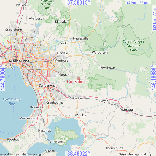
Cockatoo GPS coordinates[2]
37° 56' 12.372" South, 145° 29' 37.536" East
| Map corner | latitude | longitude |
|---|---|---|
| Upper-left | -37.38013°, | 144.79064° |
| Center: | -37.93677°, | 145.49376° |
| Lower-right: | -38.48922°, | 146.19689° |
| Map W x H: | 123.3×123.3 km | = 76.6×76.6mi |
| max Lat: | -10.58257° ⇑91.1% North |
| Cockatoo: | -37.93677° |
| min Lat: | ⇓8.9% South -43.31423° |
| min Long | Cockatoo | max Long |
| 113.53327° | 145.49376° | 153.61246° |
| W 40.4%⇐ | ⇒59.6% E |
Elevation
Elevation of Cockatoo is 215 m = 705 ft, and this is 93 m = 305 ft above average elevation for this country.
| Max E: |
1715 m = 5627 ft | 17.2% |
| Cockatoo | 215 m 705 ft | |
| Avg. | 122 m = 400 ft | |
Min E: |
-2 m = -7 ft | 82.8% |
See also: Australia elevation on elevation.city.
Geographical zone
Cockatoo is located in South temperate zone (between Tropic of Capricorn and the Antarctic Circle). Distance of this Southern Tropic circle is 1612.3 km =1001.8 mi to North.| Distance of | km | miles | from Cockatoo |
|---|---|---|---|
| Equator | 4218.2 | 2621.1 | to North |
| Tropic Capricorn | 1612.3 | 1001.8 | to North |
| Antarctic Circle | 3183 | 1977.8 | to South |
| South Pole | 5788.9 | 3597.1 | to South |


Nearby cities:
15 places around Cockatoo: (largest is in red/bold)
• Avonsleigh
2.9 km =1.8 mi,  343°
343°
• Beaconsfield Upper
9.5 km =5.9 mi,  227°
227°
• Belgrave
12.6 km =7.8 mi,  283°
283°
• Belgrave Heights
13.2 km =8.2 mi, 275°
• Emerald
4.7 km =2.9 mi, 276°
• Gembrook
5.7 km =3.5 mi,  108°
108°
• Kallista
10.7 km =6.6 mi,  293°
293°
• Macclesfield
6 km =3.7 mi,  351°
351°
• Menzies Creek
8.5 km =5.3 mi, 285°
• Monbulk
9.1 km =5.7 mi,  319°
319°
• Nar Nar Goon North
10.9 km =6.8 mi,  144°
144°
• Pakenham Upper
9.1 km =5.7 mi,  167°
167°
• Selby
9.9 km =6.2 mi, 282°
• The Patch
9.5 km =5.9 mi,  301°
301°
• Yellingbo
10.6 km =6.6 mi,  17°
17°
Sources, notices
• [Note1] Compared only with cities in Australia existing in our database
• [Src1] Map data: © OpenStreetMap contributors (CC-BY-SA)
• [Src2] Other city data from geonames.org with taken over terms of usage.
• [Src3] Geographical zone / Annual Mean Temperature by Robert A. Rohde @ Wikipedia
