Nar Nar Goon geodata
Nar Nar Goon (Victoria) is a section of populated place; located in Australia in Australia/Melbourne (GMT+11) time zone. With population of 995 people, there are 3827 cities with bigger population in this country. Compared to other cities in Australia, 92.5% of cities are located further ↑North; 59.3% of cities are located further →East and 55.9% of cities have higher elevation than Nar Nar Goon. Note1


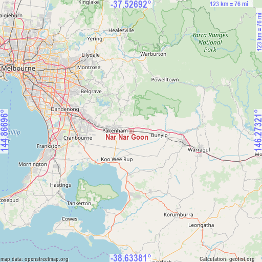
Nar Nar Goon GPS coordinates[2]
38° 4' 56.856" South, 145° 34' 12.288" East
| Map corner | latitude | longitude |
|---|---|---|
| Upper-left | -37.52692°, | 144.86696° |
| Center: | -38.08246°, | 145.57008° |
| Lower-right: | -38.63381°, | 146.27321° |
| Map W x H: | 123.1×123.1 km | = 76.5×76.5mi |
| max Lat: | -10.58257° ⇑92.5% North |
| Nar Nar Goon: | -38.08246° |
| min Lat: | ⇓7.5% South -43.31423° |
| min Long | Nar Nar Goon | max Long |
| 113.53327° | 145.57008° | 153.61246° |
| W 40.7%⇐ | ⇒59.3% E |
Elevation
Elevation of Nar Nar Goon is 37 m = 121 ft, and this is 85 m = 279 ft below average elevation for this country.
| Max E: |
1715 m = 5627 ft | 55.9% |
| Avg. | 122 m = 400 ft | |
| Nar Nar Goon | 37 m = 121 ft | |
Min E: |
-2 m = -7 ft | 44.1% |
See also: Australia elevation on elevation.city.
Geographical zone
Nar Nar Goon is located in South temperate zone (between Tropic of Capricorn and the Antarctic Circle). Distance of this Southern Tropic circle is 1628.5 km =1011.9 mi to North.| Distance of | km | miles | from Nar Nar Goon |
|---|---|---|---|
| Equator | 4234.4 | 2631.1 | to North |
| Tropic Capricorn | 1628.5 | 1011.9 | to North |
| Antarctic Circle | 3166.8 | 1967.8 | to South |
| South Pole | 5772.7 | 3587 | to South |


Nearby cities:
15 places around Nar Nar Goon: (largest is in red/bold)
• Beaconsfield
18.2 km =11.3 mi,  281°
281°
• Beaconsfield Upper
16.8 km =10.4 mi,  305°
305°
• Berwick
20 km =12.4 mi,  285°
285°
• Bunyip
12.9 km =8 mi,  97°
97°
• Cockatoo
17.5 km =10.9 mi,  337°
337°
• Emerald
20.2 km =12.6 mi,  325°
325°
• Garfield
9.2 km =5.7 mi, 95°
• Gembrook
14.4 km =8.9 mi,  354°
354°
• Koo-Wee-Rup
14.7 km =9.1 mi,  208°
208°
• Longwarry
17.7 km =11 mi, 100°
• Maryknoll
5.6 km =3.5 mi,  22°
22°
• Nar Nar Goon North
7.3 km =4.5 mi,  357°
357°
• Officer
14.3 km =8.9 mi, 280°
• Pakenham
8.5 km =5.3 mi, 279°
• Pakenham Upper
8.7 km =5.4 mi, 327°
Sources, notices
• [Note1] Compared only with cities in Australia existing in our database
• [Src1] Map data: © OpenStreetMap contributors (CC-BY-SA)
• [Src2] Other city data from geonames.org with taken over terms of usage.
• [Src3] Geographical zone / Annual Mean Temperature by Robert A. Rohde @ Wikipedia
