Avonsleigh geodata
Avonsleigh (Victoria) is a section of populated place; located in Australia in Australia/Melbourne (GMT+11) time zone. With population of 813 people, there are 4117 cities with bigger population in this country. Compared to other cities in Australia, 90.7% of cities are located further ↑North; 59.7% of cities are located further →East and 87.9% of cities have lower elevation than Avonsleigh. Note1


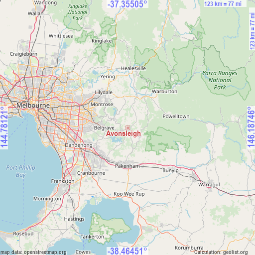
Avonsleigh GPS coordinates[2]
37° 54' 42.732" South, 145° 29' 3.588" East
| Map corner | latitude | longitude |
|---|---|---|
| Upper-left | -37.35505°, | 144.78121° |
| Center: | -37.91187°, | 145.48433° |
| Lower-right: | -38.46451°, | 146.18746° |
| Map W x H: | 123.4×123.4 km | = 76.7×76.7mi |
| max Lat: | -10.58257° ⇑90.7% North |
| Avonsleigh: | -37.91187° |
| min Lat: | ⇓9.3% South -43.31423° |
| min Long | Avonsleigh | max Long |
| 113.53327° | 145.48433° | 153.61246° |
| W 40.3%⇐ | ⇒59.7% E |
Elevation
Elevation of Avonsleigh is 309 m = 1014 ft, and this is 187 m = 614 ft above average elevation for this country.
| Max E: |
1715 m = 5627 ft | 12.1% |
| Avonsleigh | 309 m 1014 ft | |
| Avg. | 122 m = 400 ft | |
Min E: |
-2 m = -7 ft | 87.9% |
See also: Australia elevation on elevation.city.
Geographical zone
Avonsleigh is located in South temperate zone (between Tropic of Capricorn and the Antarctic Circle). Distance of this Southern Tropic circle is 1609.5 km =1000.1 mi to North.| Distance of | km | miles | from Avonsleigh |
|---|---|---|---|
| Equator | 4215.4 | 2619.3 | to North |
| Tropic Capricorn | 1609.5 | 1000.1 | to North |
| Antarctic Circle | 3185.8 | 1979.6 | to South |
| South Pole | 5791.7 | 3598.8 | to South |


Nearby cities:
15 places around Avonsleigh: (largest is in red/bold)
• Beaconsfield Upper
11 km =6.8 mi,  213°
213°
• Belgrave
11.5 km =7.1 mi,  270°
270°
• Cockatoo
2.9 km =1.8 mi,  163°
163°
• Emerald
4.4 km =2.7 mi,  239°
239°
• Gembrook
7.7 km =4.8 mi,  126°
126°
• Hoddles Creek
12.3 km =7.6 mi,  44°
44°
• Kallista
9.1 km =5.7 mi,  279°
279°
• Macclesfield
3.2 km =2 mi,  358°
358°
• Menzies Creek
7.4 km =4.6 mi, 265°
• Monbulk
6.6 km =4.1 mi,  309°
309°
• Pakenham Upper
12 km =7.5 mi,  166°
166°
• Selby
8.9 km =5.5 mi, 266°
• Silvan
12.1 km =7.5 mi,  330°
330°
• The Patch
7.5 km =4.7 mi,  287°
287°
• Yellingbo
8.3 km =5.2 mi,  28°
28°
Sources, notices
• [Note1] Compared only with cities in Australia existing in our database
• [Src1] Map data: © OpenStreetMap contributors (CC-BY-SA)
• [Src2] Other city data from geonames.org with taken over terms of usage.
• [Src3] Geographical zone / Annual Mean Temperature by Robert A. Rohde @ Wikipedia
