Pakenham geodata
Pakenham (Victoria) is a section of populated place; located in Australia in Australia/Melbourne (GMT+11) time zone. With population of 45,895 people, there are 35 cities with bigger population in this country. Compared to other cities in Australia, 92.4% of cities are located further ↑North; 59.9% of cities are located further →East and 51.1% of cities have higher elevation than Pakenham. Note1


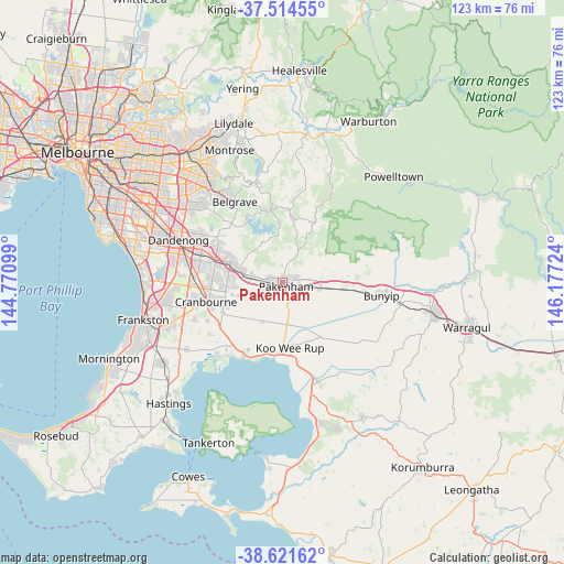
Pakenham GPS coordinates[2]
38° 4' 12.648" South, 145° 28' 26.796" East
| Map corner | latitude | longitude |
|---|---|---|
| Upper-left | -37.51455°, | 144.77099° |
| Center: | -38.07018°, | 145.47411° |
| Lower-right: | -38.62162°, | 146.17724° |
| Map W x H: | 123.1×123.1 km | = 76.5×76.5mi |
| max Lat: | -10.58257° ⇑92.4% North |
| Pakenham: | -38.07018° |
| min Lat: | ⇓7.6% South -43.31423° |
| min Long | Pakenham | max Long |
| 113.53327° | 145.47411° | 153.61246° |
| W 40.1%⇐ | ⇒59.9% E |
Elevation
Elevation of Pakenham is 44 m = 144 ft, and this is 78 m = 256 ft below average elevation for this country.
| Max E: |
1715 m = 5627 ft | 51.1% |
| Avg. | 122 m = 400 ft | |
| Pakenham | 44 m = 144 ft | |
Min E: |
-2 m = -7 ft | 48.9% |
See also: Pakenham elevation on elevation.city.
Geographical zone
Pakenham is located in South temperate zone (between Tropic of Capricorn and the Antarctic Circle). Distance of this Southern Tropic circle is 1627.1 km =1011 mi to North.| Distance of | km | miles | from Pakenham |
|---|---|---|---|
| Equator | 4233 | 2630.3 | to North |
| Tropic Capricorn | 1627.1 | 1011 | to North |
| Antarctic Circle | 3168.2 | 1968.6 | to South |
| South Pole | 5774.1 | 3587.9 | to South |


Nearby cities:
15 places around Pakenham: (largest is in red/bold)
• Beaconsfield
9.7 km =6 mi,  283°
283°
• Beaconsfield Upper
9.9 km =6.2 mi,  328°
328°
• Berwick
11.6 km =7.2 mi,  290°
290°
• Clyde
14.2 km =8.8 mi,  240°
240°
• Clyde North
13.4 km =8.3 mi,  247°
247°
• Cockatoo
14.9 km =9.3 mi,  6°
6°
• Cranbourne North
15.4 km =9.6 mi,  266°
266°
• Gembrook
14.8 km =9.2 mi,  28°
28°
• Harkaway
13.4 km =8.3 mi,  305°
305°
• Koo-Wee-Rup
14.4 km =8.9 mi,  174°
174°
• Maryknoll
11.2 km =7 mi,  70°
70°
• Nar Nar Goon
8.5 km =5.3 mi,  99°
99°
• Nar Nar Goon North
10.1 km =6.3 mi,  53°
53°
• Officer
5.8 km =3.6 mi, 282°
• Pakenham Upper
7 km =4.3 mi, 32°
Sources, notices
• [Note1] Compared only with cities in Australia existing in our database
• [Src1] Map data: © OpenStreetMap contributors (CC-BY-SA)
• [Src2] Other city data from geonames.org with taken over terms of usage.
• [Src3] Geographical zone / Annual Mean Temperature by Robert A. Rohde @ Wikipedia
