Echuca Village geodata
Echuca Village (Victoria) is a populated place; located in Australia in Australia/Melbourne (GMT+11) time zone. With population of 514 people, there are 4837 cities with bigger population in this country. Compared to other cities in Australia, 78.9% of cities are located further ↑North; 68.7% of cities are located further →East and 69.2% of cities have lower elevation than Echuca Village. Note1


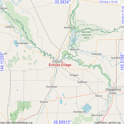
Echuca Village GPS coordinates[2]
36° 7' 59.988" South, 144° 49' 0.012" East
| Map corner | latitude | longitude |
|---|---|---|
| Upper-left | -35.5634°, | 144.11355° |
| Center: | -36.13333°, | 144.81667° |
| Lower-right: | -36.69915°, | 145.5198° |
| Map W x H: | 126.3×126.3 km | = 78.5×78.5mi |
| max Lat: | -10.58257° ⇑78.9% North |
| Echuca Village: | -36.13333° |
| min Lat: | ⇓21.1% South -43.31423° |
| min Long | Echuca Village | max Long |
| 113.53327° | 144.81667° | 153.61246° |
| W 31.3%⇐ | ⇒68.7% E |
Elevation
Elevation of Echuca Village is 98 m = 322 ft, and this is 24 m = 79 ft below average elevation for this country.
| Max E: |
1715 m = 5627 ft | 30.8% |
| Avg. | 122 m = 400 ft | |
| Echuca Village | 98 m = 322 ft | |
Min E: |
-2 m = -7 ft | 69.2% |
See also: Australia elevation on elevation.city.
Geographical zone
Echuca Village is located in South temperate zone (between Tropic of Capricorn and the Antarctic Circle). Distance of this Southern Tropic circle is 1411.7 km =877.2 mi to North.| Distance of | km | miles | from Echuca Village |
|---|---|---|---|
| Equator | 4017.6 | 2496.4 | to North |
| Tropic Capricorn | 1411.7 | 877.2 | to North |
| Antarctic Circle | 3383.5 | 2102.4 | to South |
| South Pole | 5989.4 | 3721.6 | to South |


Nearby cities:
15 places around Echuca Village: (largest is in red/bold)
• Echuca
5.9 km =3.7 mi,  262°
262°
• Elmore
44.2 km =27.5 mi,  204°
204°
• Girgarre
31.9 km =19.8 mi,  158°
158°
• Gunbower
44.8 km =27.8 mi,  296°
296°
• Kyabram
29 km =18 mi,  133°
133°
• Leitchville
52.8 km =32.8 mi, 298°
• Lockington
29.4 km =18.3 mi,  238°
238°
• Mathoura
36.2 km =22.5 mi,  12°
12°
• Merrigum
38.8 km =24.1 mi, 133°
• Moama
6 km =3.7 mi, 302°
• Nathalia
35.8 km =22.2 mi,  76°
76°
• Rochester
27.6 km =17.1 mi, 202°
• Stanhope
37.9 km =23.5 mi, 156°
• Tatura
50.3 km =31.3 mi, 132°
• Tongala
18.4 km =11.4 mi,  137°
137°
Sources, notices
• [Note1] Compared only with cities in Australia existing in our database
• [Src1] Map data: © OpenStreetMap contributors (CC-BY-SA)
• [Src2] Other city data from geonames.org with taken over terms of usage.
• [Src3] Geographical zone / Annual Mean Temperature by Robert A. Rohde @ Wikipedia
