Leitchville geodata
Leitchville (Victoria) is a populated place; located in Australia in Australia/Melbourne (GMT+11) time zone. With population of 543 people, there are 4731 cities with bigger population in this country. Compared to other cities in Australia, 78.1% of cities are located further ↑North; 71.4% of cities are located further →East and 67% of cities have lower elevation than Leitchville. Note1


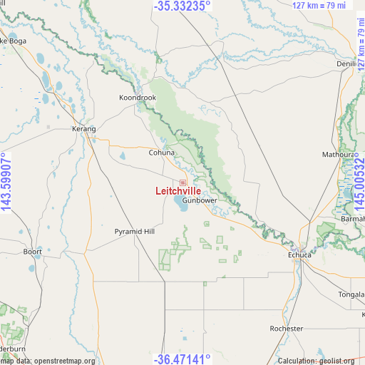
Leitchville GPS coordinates[2]
35° 54' 14.148" South, 144° 18' 7.884" East
| Map corner | latitude | longitude |
|---|---|---|
| Upper-left | -35.33235°, | 143.59907° |
| Center: | -35.90393°, | 144.30219° |
| Lower-right: | -36.47141°, | 145.00532° |
| Map W x H: | 126.7×126.7 km | = 78.7×78.7mi |
| max Lat: | -10.58257° ⇑78.1% North |
| Leitchville: | -35.90393° |
| min Lat: | ⇓21.9% South -43.31423° |
| min Long | Leitchville | max Long |
| 113.53327° | 144.30219° | 153.61246° |
| W 28.6%⇐ | ⇒71.4% E |
Elevation
Elevation of Leitchville is 88 m = 289 ft, and this is 34 m = 112 ft below average elevation for this country.
| Max E: |
1715 m = 5627 ft | 33% |
| Avg. | 122 m = 400 ft | |
| Leitchville | 88 m = 289 ft | |
Min E: |
-2 m = -7 ft | 67% |
See also: Australia elevation on elevation.city.
Geographical zone
Leitchville is located in South temperate zone (between Tropic of Capricorn and the Antarctic Circle). Distance of this Southern Tropic circle is 1386.2 km =861.3 mi to North.| Distance of | km | miles | from Leitchville |
|---|---|---|---|
| Equator | 3992.1 | 2480.6 | to North |
| Tropic Capricorn | 1386.2 | 861.3 | to North |
| Antarctic Circle | 3409 | 2118.3 | to South |
| South Pole | 6014.9 | 3737.5 | to South |


Nearby cities:
15 places around Leitchville: (largest is in red/bold)
• Barham
34.6 km =21.5 mi,  333°
333°
• Boort
57.4 km =35.7 mi,  245°
245°
• Cohuna
13.1 km =8.1 mi, 325°
• Echuca
48.2 km =30 mi,  123°
123°
• Echuca Village
52.8 km =32.8 mi, 118°
• Elmore
71.3 km =44.3 mi,  157°
157°
• Gunbower
8.4 km =5.2 mi,  133°
133°
• Kerang
39.2 km =24.4 mi,  298°
298°
• Koondrook
34.2 km =21.3 mi, 332°
• Lockington
46 km =28.6 mi,  152°
152°
• Mathoura
54.9 km =34.1 mi,  79°
79°
• Moama
46.9 km =29.1 mi, 118°
• Pyramid Hill
23.9 km =14.9 mi,  224°
224°
• Rochester
62.4 km =38.8 mi,  144°
144°
• Tongala
70.5 km =43.8 mi, 123°
Sources, notices
• [Note1] Compared only with cities in Australia existing in our database
• [Src1] Map data: © OpenStreetMap contributors (CC-BY-SA)
• [Src2] Other city data from geonames.org with taken over terms of usage.
• [Src3] Geographical zone / Annual Mean Temperature by Robert A. Rohde @ Wikipedia
