Echuca geodata
Echuca (Victoria) is a populated place; located in Australia in Australia/Melbourne (GMT+11) time zone. With population of 13,927 people, there are 317 cities with bigger population in this country. Compared to other cities in Australia, 79% of cities are located further ↑North; 69.3% of cities are located further →East and 69.5% of cities have lower elevation than Echuca. Note1


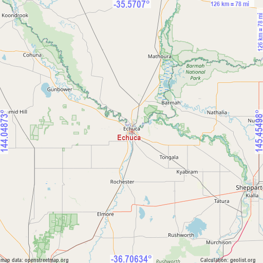
Echuca GPS coordinates[2]
36° 8' 26.052" South, 144° 45' 6.66" East
| Map corner | latitude | longitude |
|---|---|---|
| Upper-left | -35.5707°, | 144.04873° |
| Center: | -36.14057°, | 144.75185° |
| Lower-right: | -36.70634°, | 145.45498° |
| Map W x H: | 126.3×126.3 km | = 78.5×78.5mi |
| max Lat: | -10.58257° ⇑79% North |
| Echuca: | -36.14057° |
| min Lat: | ⇓21% South -43.31423° |
| min Long | Echuca | max Long |
| 113.53327° | 144.75185° | 153.61246° |
| W 30.7%⇐ | ⇒69.3% E |
Elevation
Elevation of Echuca is 100 m = 328 ft, and this is 22 m = 72 ft below average elevation for this country.
| Max E: |
1715 m = 5627 ft | 30.5% |
| Avg. | 122 m = 400 ft | |
| Echuca | 100 m = 328 ft | |
Min E: |
-2 m = -7 ft | 69.5% |
See also: Australia elevation on elevation.city.
Geographical zone
Echuca is located in South temperate zone (between Tropic of Capricorn and the Antarctic Circle). Distance of this Southern Tropic circle is 1412.5 km =877.7 mi to North.| Distance of | km | miles | from Echuca |
|---|---|---|---|
| Equator | 4018.5 | 2497 | to North |
| Tropic Capricorn | 1412.5 | 877.7 | to North |
| Antarctic Circle | 3382.7 | 2101.9 | to South |
| South Pole | 5988.6 | 3721.1 | to South |


Nearby cities:
15 places around Echuca: (largest is in red/bold)
• Echuca Village
5.9 km =3.7 mi,  82°
82°
• Elmore
41.4 km =25.7 mi,  197°
197°
• Girgarre
33.8 km =21 mi,  148°
148°
• Gunbower
40 km =24.9 mi,  300°
300°
• Kyabram
33 km =20.5 mi,  125°
125°
• Leitchville
48.2 km =30 mi, 303°
• Lockington
24.1 km =15 mi,  232°
232°
• Mathoura
38.6 km =24 mi,  20°
20°
• Merrigum
42.7 km =26.5 mi, 127°
• Moama
4.1 km =2.5 mi,  11°
11°
• Nathalia
41.7 km =25.9 mi, 77°
• Rochester
25.2 km =15.7 mi,  190°
190°
• Stanhope
39.9 km =24.8 mi, 148°
• Tatura
54.2 km =33.7 mi, 127°
• Tongala
22.3 km =13.9 mi,  124°
124°
Sources, notices
• [Note1] Compared only with cities in Australia existing in our database
• [Src1] Map data: © OpenStreetMap contributors (CC-BY-SA)
• [Src2] Other city data from geonames.org with taken over terms of usage.
• [Src3] Geographical zone / Annual Mean Temperature by Robert A. Rohde @ Wikipedia
