Dugandan geodata
Dugandan (Queensland) is a populated place; located in Australia in Australia/Brisbane (GMT+10) time zone. With population of 581 people, there are 4620 cities with bigger population in this country. Compared to other cities in Australia, 76% of cities are located further ↓South; 85.5% of cities are located further ←West and 69.8% of cities have lower elevation than Dugandan. Note1


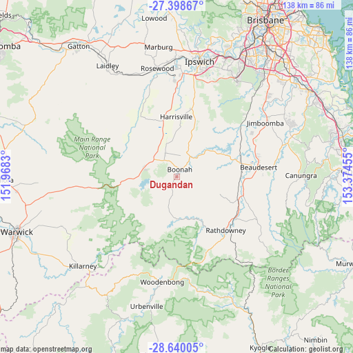
Dugandan GPS coordinates[2]
28° 1' 16.14" South, 152° 40' 17.112" East
| Map corner | latitude | longitude |
|---|---|---|
| Upper-left | -27.39867°, | 151.9683° |
| Center: | -28.02115°, | 152.67142° |
| Lower-right: | -28.64005°, | 153.37455° |
| Map W x H: | 138×138 km | = 85.7×85.7mi |
| max Lat: | -10.58257° ⇑24% North |
| Dugandan: | -28.02115° |
| min Lat: | ⇓76% South -43.31423° |
| min Long | Dugandan | max Long |
| 113.53327° | 152.67142° | 153.61246° |
| W 85.5%⇐ | ⇒14.5% E |
Elevation
Elevation of Dugandan is 102 m = 335 ft, and this is 20 m = 66 ft below average elevation for this country.
| Max E: |
1715 m = 5627 ft | 30.2% |
| Avg. | 122 m = 400 ft | |
| Dugandan | 102 m = 335 ft | |
Min E: |
-2 m = -7 ft | 69.8% |
See also: Australia elevation on elevation.city.
Geographical zone
Dugandan is located in South temperate zone (between Tropic of Capricorn and the Antarctic Circle). Distance of this Southern Tropic circle is 509.7 km =316.7 mi to North.| Distance of | km | miles | from Dugandan |
|---|---|---|---|
| Equator | 3115.7 | 1936 | to North |
| Tropic Capricorn | 509.7 | 316.7 | to North |
| Antarctic Circle | 4285.5 | 2662.9 | to South |
| South Pole | 6891.4 | 4282.1 | to South |


Nearby cities:
15 places around Dugandan: (largest is in red/bold)
• Aratula
14.2 km =8.8 mi,  287°
287°
• Beaudesert
32.1 km =19.9 mi,  83°
83°
• Boonah
2.8 km =1.7 mi,  19°
19°
• Cedar Grove
35.1 km =21.8 mi,  60°
60°
• Cedar Vale
38.1 km =23.7 mi,  67°
67°
• Gleneagle
32.1 km =19.9 mi, 72°
• Harrisville
23.4 km =14.5 mi,  358°
358°
• Kalbar
10 km =6.2 mi,  332°
332°
• Kooralbyn
17.7 km =11 mi,  111°
111°
• New Beith
32.8 km =20.4 mi,  39°
39°
• Peak Crossing
26.9 km =16.7 mi,  11°
11°
• Ripley
37.4 km =23.2 mi,  25°
25°
• South Ripley
36.7 km =22.8 mi, 22°
• Willowbank
37.7 km =23.4 mi,  0°
0°
• Woodhill
32 km =19.9 mi, 65°
Sources, notices
• [Note1] Compared only with cities in Australia existing in our database
• [Src1] Map data: © OpenStreetMap contributors (CC-BY-SA)
• [Src2] Other city data from geonames.org with taken over terms of usage.
• [Src3] Geographical zone / Annual Mean Temperature by Robert A. Rohde @ Wikipedia
