Kooralbyn geodata
Kooralbyn (Queensland) is a populated place; located in Australia in Australia/Brisbane (GMT+10) time zone. With population of 1,707 people, there are 3103 cities with bigger population in this country. Compared to other cities in Australia, 75.6% of cities are located further ↓South; 87.6% of cities are located further ←West and 72.9% of cities have lower elevation than Kooralbyn. Note1


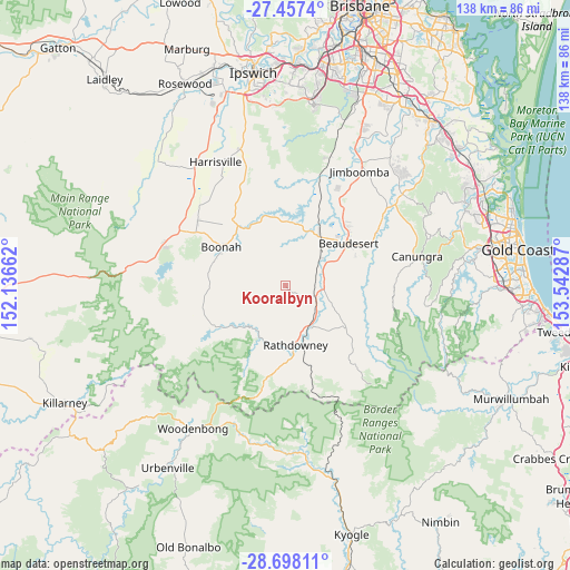
Kooralbyn GPS coordinates[2]
28° 4' 46.38" South, 152° 50' 23.064" East
| Map corner | latitude | longitude |
|---|---|---|
| Upper-left | -27.4574°, | 152.13662° |
| Center: | -28.07955°, | 152.83974° |
| Lower-right: | -28.69811°, | 153.54287° |
| Map W x H: | 138×138 km | = 85.7×85.7mi |
| max Lat: | -10.58257° ⇑24.4% North |
| Kooralbyn: | -28.07955° |
| min Lat: | ⇓75.6% South -43.31423° |
| min Long | Kooralbyn | max Long |
| 113.53327° | 152.83974° | 153.61246° |
| W 87.6%⇐ | ⇒12.4% E |
Elevation
Elevation of Kooralbyn is 117 m = 384 ft, and this is 5 m = 16 ft below average elevation for this country.
| Max E: |
1715 m = 5627 ft | 27.1% |
| Avg. | 122 m = 400 ft | |
| Kooralbyn | 117 m = 384 ft | |
Min E: |
-2 m = -7 ft | 72.9% |
See also: Australia elevation on elevation.city.
Geographical zone
Kooralbyn is located in South temperate zone (between Tropic of Capricorn and the Antarctic Circle). Distance of this Southern Tropic circle is 516.2 km =320.8 mi to North.| Distance of | km | miles | from Kooralbyn |
|---|---|---|---|
| Equator | 3122.2 | 1940 | to North |
| Tropic Capricorn | 516.2 | 320.8 | to North |
| Antarctic Circle | 4279 | 2658.8 | to South |
| South Pole | 6884.9 | 4278.1 | to South |


Nearby cities:
15 places around Kooralbyn: (largest is in red/bold)
• Aratula
31.9 km =19.8 mi,  289°
289°
• Beaudesert
18.5 km =11.5 mi,  56°
56°
• Boonah
18.1 km =11.2 mi,  300°
300°
• Boyland
32.2 km =20 mi, 63°
• Canungra
32.7 km =20.3 mi,  77°
77°
• Cedar Grove
27.6 km =17.1 mi,  30°
30°
• Cedar Vale
28.2 km =17.5 mi,  41°
41°
• Dugandan
17.7 km =11 mi, 291°
• Gleneagle
21.5 km =13.4 mi, 40°
• Harrisville
34.5 km =21.4 mi,  330°
330°
• Jimboomba
33.2 km =20.6 mi, 33°
• Kalbar
26.2 km =16.3 mi,  305°
305°
• Mundoolun
30.3 km =18.8 mi,  48°
48°
• New Beith
32.1 km =19.9 mi,  7°
7°
• Woodhill
23.5 km =14.6 mi, 31°
Sources, notices
• [Note1] Compared only with cities in Australia existing in our database
• [Src1] Map data: © OpenStreetMap contributors (CC-BY-SA)
• [Src2] Other city data from geonames.org with taken over terms of usage.
• [Src3] Geographical zone / Annual Mean Temperature by Robert A. Rohde @ Wikipedia
