Pheasants Nest geodata
Pheasants Nest (New South Wales) is a section of populated place; located in Australia in Australia/Sydney (GMT+11) time zone. With population of 666 people, there are 4391 cities with bigger population in this country. Compared to other cities in Australia, 61.5% of cities are located further ↑North; 59.9% of cities are located further ←West and 84.5% of cities have lower elevation than Pheasants Nest. Note1


Pheasants Nest GPS coordinates[2]
34° 15' 21.024" South, 150° 38' 2.544" East
| Map corner | latitude | longitude |
|---|---|---|
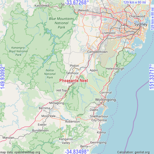
| Upper-left | -33.67268°, | 149.93092° |
| Center: | -34.25584°, | 150.63404° |
| Lower-right: | -34.83498°, | 151.33717° |
| Map W x H: | 129.2×129.2 km | = 80.3×80.3mi |
| max Lat: | -10.58257° ⇑61.5% North |
| Pheasants Nest: | -34.25584° |
| min Lat: | ⇓38.5% South -43.31423° |
| min Long | Pheasants Nest | max Long |
| 113.53327° | 150.63404° | 153.61246° |
| W 59.9%⇐ | ⇒40.1% E |
Elevation
Elevation of Pheasants Nest is 240 m = 787 ft, and this is 118 m = 387 ft above average elevation for this country.
| Max E: |
1715 m = 5627 ft | 15.5% |
| Pheasants Nest | 240 m 787 ft | |
| Avg. | 122 m = 400 ft | |
Min E: |
-2 m = -7 ft | 84.5% |
See also: Australia elevation on elevation.city.
Geographical zone
Pheasants Nest is located in South temperate zone (between Tropic of Capricorn and the Antarctic Circle). Distance of this Southern Tropic circle is 1203 km =747.5 mi to North.| Distance of | km | miles | from Pheasants Nest |
|---|---|---|---|
| Equator | 3808.9 | 2366.7 | to North |
| Tropic Capricorn | 1203 | 747.5 | to North |
| Antarctic Circle | 3592.3 | 2232.2 | to South |
| South Pole | 6198.2 | 3851.4 | to South |


Nearby cities:
15 places around Pheasants Nest: (largest is in red/bold)
• Appin
15.2 km =9.4 mi,  67°
67°
• Bargo
6.6 km =4.1 mi,  231°
231°
• Buxton
9.3 km =5.8 mi,  267°
267°
• Camden South
20 km =12.4 mi,  16°
16°
• Douglas Park
10.8 km =6.7 mi,  43°
43°
• Hill Top
16.3 km =10.1 mi, 231°
• Menangle
17.3 km =10.7 mi,  33°
33°
• Picton
9.8 km =6.1 mi,  347°
347°
• Razorback
11.6 km =7.2 mi,  8°
8°
• Tahmoor
5.2 km =3.2 mi,  315°
315°
• The Oaks
20.4 km =12.7 mi,  343°
343°
• Thirlmere
8.4 km =5.2 mi,  313°
313°
• Wilton
6.1 km =3.8 mi, 73°
• Yanderra
8.9 km =5.5 mi,  217°
217°
• Yerrinbool
15.3 km =9.5 mi,  214°
214°
Sources, notices
• [Note1] Compared only with cities in Australia existing in our database
• [Src1] Map data: © OpenStreetMap contributors (CC-BY-SA)
• [Src2] Other city data from geonames.org with taken over terms of usage.
• [Src3] Geographical zone / Annual Mean Temperature by Robert A. Rohde @ Wikipedia
