Cooranbong geodata
Cooranbong (New South Wales) is a section of populated place; located in Australia in Australia/Sydney (GMT+11) time zone. With population of 5,377 people, there are 1384 cities with bigger population in this country. Compared to other cities in Australia, 56.9% of cities are located further ↓South; 77.3% of cities are located further ←West and 77.5% of cities have higher elevation than Cooranbong. Note1


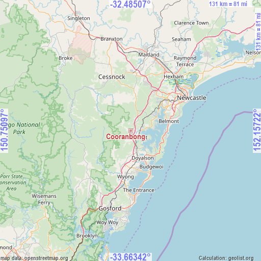
Cooranbong GPS coordinates[2]
33° 4' 34.392" South, 151° 27' 14.724" East
| Map corner | latitude | longitude |
|---|---|---|
| Upper-left | -32.48507°, | 150.75097° |
| Center: | -33.07622°, | 151.45409° |
| Lower-right: | -33.66342°, | 152.15722° |
| Map W x H: | 131×131 km | = 81.4×81.4mi |
| max Lat: | -10.58257° ⇑43.1% North |
| Cooranbong: | -33.07622° |
| min Lat: | ⇓56.9% South -43.31423° |
| min Long | Cooranbong | max Long |
| 113.53327° | 151.45409° | 153.61246° |
| W 77.3%⇐ | ⇒22.7% E |
Elevation
Elevation of Cooranbong is 17 m = 56 ft, and this is 105 m = 344 ft below average elevation for this country.
| Max E: |
1715 m = 5627 ft | 77.5% |
| Avg. | 122 m = 400 ft | |
| Cooranbong | 17 m = 56 ft | |
Min E: |
-2 m = -7 ft | 22.5% |
See also: Australia elevation on elevation.city.
Geographical zone
Cooranbong is located in South temperate zone (between Tropic of Capricorn and the Antarctic Circle). Distance of this Southern Tropic circle is 1071.8 km =666 mi to North.| Distance of | km | miles | from Cooranbong |
|---|---|---|---|
| Equator | 3677.7 | 2285.2 | to North |
| Tropic Capricorn | 1071.8 | 666 | to North |
| Antarctic Circle | 3723.4 | 2313.6 | to South |
| South Pole | 6329.3 | 3932.8 | to South |


Nearby cities:
15 places around Cooranbong: (largest is in red/bold)
• Arcadia vale
12.2 km =7.6 mi,  81°
81°
• Balcolyn
9.4 km =5.8 mi,  103°
103°
• Bonnells Bay
8.2 km =5.1 mi,  117°
117°
• Brightwaters
9.4 km =5.8 mi, 116°
• Buttaba
11.9 km =7.4 mi, 77°
• Dora Creek
4 km =2.5 mi, 98°
• Mannering Park
11.8 km =7.3 mi,  140°
140°
• Mirrabooka
10.1 km =6.3 mi,  112°
112°
• Morisset
4.7 km =2.9 mi, 139°
• Morisset Park
9.1 km =5.7 mi, 122°
• Rathmines
12.9 km =8 mi,  70°
70°
• Summerland Point
12.6 km =7.8 mi, 124°
• Windermere Park
8.7 km =5.4 mi, 124°
• Wyee
12.2 km =7.6 mi,  165°
165°
• Wyee Point
9.2 km =5.7 mi,  147°
147°
Sources, notices
• [Note1] Compared only with cities in Australia existing in our database
• [Src1] Map data: © OpenStreetMap contributors (CC-BY-SA)
• [Src2] Other city data from geonames.org with taken over terms of usage.
• [Src3] Geographical zone / Annual Mean Temperature by Robert A. Rohde @ Wikipedia
