Cargo geodata
Cargo (New South Wales) is a populated place; located in Australia in Australia/Sydney (GMT+11) time zone. With population of 581 people, there are 4620 cities with bigger population in this country. Compared to other cities in Australia, 54.2% of cities are located further ↓South; 52.3% of cities are located further ←West and 95.6% of cities have lower elevation than Cargo. Note1


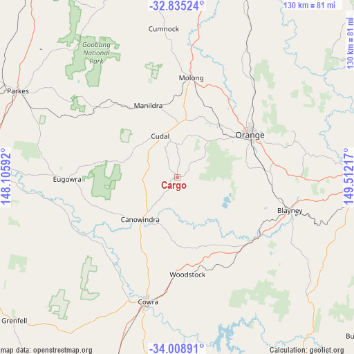
Cargo GPS coordinates[2]
33° 25' 26.616" South, 148° 48' 32.544" East
| Map corner | latitude | longitude |
|---|---|---|
| Upper-left | -32.83524°, | 148.10592° |
| Center: | -33.42406°, | 148.80904° |
| Lower-right: | -34.00891°, | 149.51217° |
| Map W x H: | 130.5×130.5 km | = 81.1×81.1mi |
| max Lat: | -10.58257° ⇑45.8% North |
| Cargo: | -33.42406° |
| min Lat: | ⇓54.2% South -43.31423° |
| min Long | Cargo | max Long |
| 113.53327° | 148.80904° | 153.61246° |
| W 52.3%⇐ | ⇒47.7% E |
Elevation
Elevation of Cargo is 595 m = 1952 ft, and this is 473 m = 1552 ft above average elevation for this country.
| Max E: |
1715 m = 5627 ft | 4.4% |
| Cargo | 595 m 1952 ft | |
| Avg. | 122 m = 400 ft | |
Min E: |
-2 m = -7 ft | 95.6% |
See also: Australia elevation on elevation.city.
Geographical zone
Cargo is located in South temperate zone (between Tropic of Capricorn and the Antarctic Circle). Distance of this Southern Tropic circle is 1110.5 km =690 mi to North.| Distance of | km | miles | from Cargo |
|---|---|---|---|
| Equator | 3716.4 | 2309.3 | to North |
| Tropic Capricorn | 1110.5 | 690 | to North |
| Antarctic Circle | 3684.8 | 2289.6 | to South |
| South Pole | 6290.7 | 3908.9 | to South |


Nearby cities:
15 places around Cargo: (largest is in red/bold)
• Blayney
43 km =26.7 mi,  106°
106°
• Canowindra
20.4 km =12.7 mi,  221°
221°
• Clifton Grove
37.3 km =23.2 mi,  59°
59°
• Cowra
46.9 km =29.1 mi,  192°
192°
• Cudal
16.6 km =10.3 mi,  337°
337°
• Eugowra
40.6 km =25.2 mi,  269°
269°
• Forest Reefs
25.5 km =15.8 mi,  100°
100°
• Manildra
29.1 km =18.1 mi, 337°
• Millthorpe
35 km =21.7 mi,  93°
93°
• Molong
37.3 km =23.2 mi,  8°
8°
• Mullion Creek
44.5 km =27.7 mi,  41°
41°
• Orange
31.2 km =19.4 mi, 60°
• Parkes
66.9 km =41.6 mi,  298°
298°
• Robin Hill
67.2 km =41.8 mi, 89°
• Woodstock
35.8 km =22.2 mi,  174°
174°
Sources, notices
• [Note1] Compared only with cities in Australia existing in our database
• [Src1] Map data: © OpenStreetMap contributors (CC-BY-SA)
• [Src2] Other city data from geonames.org with taken over terms of usage.
• [Src3] Geographical zone / Annual Mean Temperature by Robert A. Rohde @ Wikipedia
