Canowindra geodata
Canowindra (New South Wales) is a populated place; located in Australia in Australia/Sydney (GMT+11) time zone. With population of 2,260 people, there are 2722 cities with bigger population in this country. Compared to other cities in Australia, 52.9% of cities are located further ↓South; 52% of cities are located further ←West and 87.6% of cities have lower elevation than Canowindra. Note1


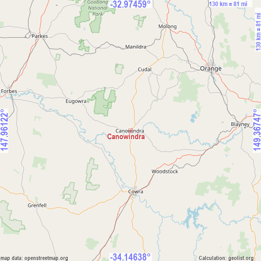
Canowindra GPS coordinates[2]
33° 33' 44.892" South, 148° 39' 51.624" East
| Map corner | latitude | longitude |
|---|---|---|
| Upper-left | -32.97459°, | 147.96122° |
| Center: | -33.56247°, | 148.66434° |
| Lower-right: | -34.14638°, | 149.36747° |
| Map W x H: | 130.3×130.3 km | = 81×81mi |
| max Lat: | -10.58257° ⇑47.1% North |
| Canowindra: | -33.56247° |
| min Lat: | ⇓52.9% South -43.31423° |
| min Long | Canowindra | max Long |
| 113.53327° | 148.66434° | 153.61246° |
| W 52%⇐ | ⇒48% E |
Elevation
Elevation of Canowindra is 304 m = 997 ft, and this is 182 m = 597 ft above average elevation for this country.
| Max E: |
1715 m = 5627 ft | 12.4% |
| Canowindra | 304 m 997 ft | |
| Avg. | 122 m = 400 ft | |
Min E: |
-2 m = -7 ft | 87.6% |
See also: Australia elevation on elevation.city.
Geographical zone
Canowindra is located in South temperate zone (between Tropic of Capricorn and the Antarctic Circle). Distance of this Southern Tropic circle is 1125.9 km =699.6 mi to North.| Distance of | km | miles | from Canowindra |
|---|---|---|---|
| Equator | 3731.8 | 2318.8 | to North |
| Tropic Capricorn | 1125.9 | 699.6 | to North |
| Antarctic Circle | 3669.4 | 2280.1 | to South |
| South Pole | 6275.3 | 3899.3 | to South |


Nearby cities:
15 places around Canowindra: (largest is in red/bold)
• Blayney
54.7 km =34 mi,  86°
86°
• Cargo
20.4 km =12.7 mi,  41°
41°
• Clifton Grove
57 km =35.4 mi,  53°
53°
• Cowra
30.5 km =19 mi,  174°
174°
• Cudal
31.6 km =19.6 mi,  12°
12°
• Eugowra
31 km =19.3 mi,  298°
298°
• Forbes
64 km =39.8 mi,  288°
288°
• Forest Reefs
40 km =24.9 mi,  74°
74°
• Grenfell
59.2 km =36.8 mi,  231°
231°
• Manildra
42.3 km =26.3 mi,  3°
3°
• Millthorpe
50 km =31.1 mi, 74°
• Molong
55.7 km =34.6 mi,  20°
20°
• Mullion Creek
64.9 km =40.3 mi, 41°
• Orange
50.9 km =31.6 mi, 52°
• Woodstock
26.5 km =16.5 mi,  139°
139°
Sources, notices
• [Note1] Compared only with cities in Australia existing in our database
• [Src1] Map data: © OpenStreetMap contributors (CC-BY-SA)
• [Src2] Other city data from geonames.org with taken over terms of usage.
• [Src3] Geographical zone / Annual Mean Temperature by Robert A. Rohde @ Wikipedia
