Manildra geodata
Manildra (New South Wales) is a populated place; located in Australia in Australia/Sydney (GMT+11) time zone. With population of 749 people, there are 4243 cities with bigger population in this country. Compared to other cities in Australia, 56.3% of cities are located further ↓South; 52.1% of cities are located further ←West and 92.3% of cities have lower elevation than Manildra. Note1


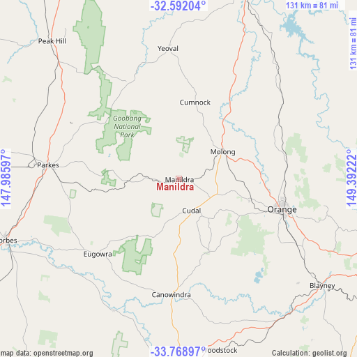
Manildra GPS coordinates[2]
33° 10' 56.928" South, 148° 41' 20.724" East
| Map corner | latitude | longitude |
|---|---|---|
| Upper-left | -32.59204°, | 147.98597° |
| Center: | -33.18248°, | 148.68909° |
| Lower-right: | -33.76897°, | 149.39222° |
| Map W x H: | 130.9×130.9 km | = 81.3×81.3mi |
| max Lat: | -10.58257° ⇑43.7% North |
| Manildra: | -33.18248° |
| min Lat: | ⇓56.3% South -43.31423° |
| min Long | Manildra | max Long |
| 113.53327° | 148.68909° | 153.61246° |
| W 52.1%⇐ | ⇒47.9% E |
Elevation
Elevation of Manildra is 449 m = 1473 ft, and this is 327 m = 1073 ft above average elevation for this country.
| Max E: |
1715 m = 5627 ft | 7.7% |
| Manildra | 449 m 1473 ft | |
| Avg. | 122 m = 400 ft | |
Min E: |
-2 m = -7 ft | 92.3% |
See also: Australia elevation on elevation.city.
Geographical zone
Manildra is located in South temperate zone (between Tropic of Capricorn and the Antarctic Circle). Distance of this Southern Tropic circle is 1083.6 km =673.3 mi to North.| Distance of | km | miles | from Manildra |
|---|---|---|---|
| Equator | 3689.5 | 2292.5 | to North |
| Tropic Capricorn | 1083.6 | 673.3 | to North |
| Antarctic Circle | 3711.6 | 2306.3 | to South |
| South Pole | 6317.5 | 3925.5 | to South |


Nearby cities:
15 places around Manildra: (largest is in red/bold)
• Blayney
65.3 km =40.6 mi,  126°
126°
• Canowindra
42.3 km =26.3 mi,  183°
183°
• Cargo
29.1 km =18.1 mi,  157°
157°
• Clifton Grove
44.2 km =27.5 mi,  100°
100°
• Cudal
12.4 km =7.7 mi, 157°
• Eugowra
40.2 km =25 mi,  227°
227°
• Forbes
67.2 km =41.8 mi,  250°
250°
• Forest Reefs
47.9 km =29.8 mi, 130°
• Millthorpe
54.6 km =33.9 mi,  122°
122°
• Molong
19.6 km =12.2 mi,  59°
59°
• Mullion Creek
41.3 km =25.7 mi,  81°
81°
• Orange
39.9 km =24.8 mi,  106°
106°
• Parkes
48 km =29.8 mi,  276°
276°
• Peak Hill
69 km =42.9 mi,  317°
317°
• Woodstock
64.2 km =39.9 mi,  166°
166°
Sources, notices
• [Note1] Compared only with cities in Australia existing in our database
• [Src1] Map data: © OpenStreetMap contributors (CC-BY-SA)
• [Src2] Other city data from geonames.org with taken over terms of usage.
• [Src3] Geographical zone / Annual Mean Temperature by Robert A. Rohde @ Wikipedia
