Campbells Creek geodata
Campbells Creek (Victoria) is a populated place; located in Australia in Australia/Melbourne (GMT+11) time zone. With population of 1,722 people, there are 3094 cities with bigger population in this country. Compared to other cities in Australia, 81.7% of cities are located further ↑North; 72% of cities are located further →East and 86.1% of cities have lower elevation than Campbells Creek. Note1


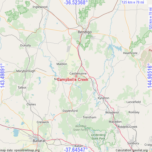
Campbells Creek GPS coordinates[2]
37° 5' 11.94" South, 144° 12' 7.308" East
| Map corner | latitude | longitude |
|---|---|---|
| Upper-left | -36.52368°, | 143.49891° |
| Center: | -37.08665°, | 144.20203° |
| Lower-right: | -37.64547°, | 144.90516° |
| Map W x H: | 124.7×124.7 km | = 77.5×77.5mi |
| max Lat: | -10.58257° ⇑81.7% North |
| Campbells Creek: | -37.08665° |
| min Lat: | ⇓18.3% South -43.31423° |
| min Long | Campbells Creek | max Long |
| 113.53327° | 144.20203° | 153.61246° |
| W 28%⇐ | ⇒72% E |
Elevation
Elevation of Campbells Creek is 269 m = 883 ft, and this is 147 m = 482 ft above average elevation for this country.
| Max E: |
1715 m = 5627 ft | 13.9% |
| Campbells Creek | 269 m 883 ft | |
| Avg. | 122 m = 400 ft | |
Min E: |
-2 m = -7 ft | 86.1% |
See also: Australia elevation on elevation.city.
Geographical zone
Campbells Creek is located in South temperate zone (between Tropic of Capricorn and the Antarctic Circle). Distance of this Southern Tropic circle is 1517.7 km =943.1 mi to North.| Distance of | km | miles | from Campbells Creek |
|---|---|---|---|
| Equator | 4123.6 | 2562.3 | to North |
| Tropic Capricorn | 1517.7 | 943.1 | to North |
| Antarctic Circle | 3277.5 | 2036.5 | to South |
| South Pole | 5883.4 | 3655.8 | to South |


Nearby cities:
15 places around Campbells Creek: (largest is in red/bold)
• Castlemaine
2.5 km =1.6 mi,  31°
31°
• Chewton
4.9 km =3 mi,  83°
83°
• Daylesford
28.8 km =17.9 mi,  190°
190°
• Elphinstone
11.7 km =7.3 mi,  97°
97°
• Harcourt
10.9 km =6.8 mi, 27°
• Hepburn
26.3 km =16.3 mi, 193°
• Kangaroo Flat
32.2 km =20 mi,  7°
7°
• Kyneton
28.2 km =17.5 mi,  128°
128°
• Lockwood
30.9 km =19.2 mi,  352°
352°
• Lockwood South
27.3 km =17 mi, 351°
• Maldon
15.6 km =9.7 mi,  310°
310°
• Malmsbury
19.8 km =12.3 mi,  124°
124°
• Mandurang
31.3 km =19.4 mi,  16°
16°
• Newstead
12.4 km =7.7 mi,  259°
259°
• Sedgwick
24.8 km =15.4 mi, 24°
Sources, notices
• [Note1] Compared only with cities in Australia existing in our database
• [Src1] Map data: © OpenStreetMap contributors (CC-BY-SA)
• [Src2] Other city data from geonames.org with taken over terms of usage.
• [Src3] Geographical zone / Annual Mean Temperature by Robert A. Rohde @ Wikipedia
