Kyneton geodata
Kyneton (Victoria) is a populated place; located in Australia in Australia/Melbourne (GMT+11) time zone. With population of 6,904 people, there are 995 cities with bigger population in this country. Compared to other cities in Australia, 82% of cities are located further ↑North; 70.4% of cities are located further →East and 93.7% of cities have lower elevation than Kyneton. Note1


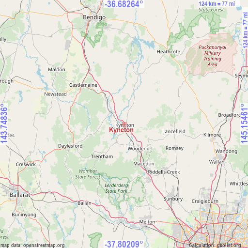
Kyneton GPS coordinates[2]
37° 14' 39.984" South, 144° 27' 5.328" East
| Map corner | latitude | longitude |
|---|---|---|
| Upper-left | -36.68264°, | 143.74836° |
| Center: | -37.24444°, | 144.45148° |
| Lower-right: | -37.80209°, | 145.15461° |
| Map W x H: | 124.5×124.5 km | = 77.4×77.4mi |
| max Lat: | -10.58257° ⇑82% North |
| Kyneton: | -37.24444° |
| min Lat: | ⇓18% South -43.31423° |
| min Long | Kyneton | max Long |
| 113.53327° | 144.45148° | 153.61246° |
| W 29.6%⇐ | ⇒70.4% E |
Elevation
Elevation of Kyneton is 514 m = 1686 ft, and this is 392 m = 1286 ft above average elevation for this country.
| Max E: |
1715 m = 5627 ft | 6.3% |
| Kyneton | 514 m 1686 ft | |
| Avg. | 122 m = 400 ft | |
Min E: |
-2 m = -7 ft | 93.7% |
See also: Australia elevation on elevation.city.
Geographical zone
Kyneton is located in South temperate zone (between Tropic of Capricorn and the Antarctic Circle). Distance of this Southern Tropic circle is 1535.3 km =954 mi to North.| Distance of | km | miles | from Kyneton |
|---|---|---|---|
| Equator | 4141.2 | 2573.2 | to North |
| Tropic Capricorn | 1535.3 | 954 | to North |
| Antarctic Circle | 3260 | 2025.7 | to South |
| South Pole | 5865.9 | 3644.9 | to South |


Nearby cities:
15 places around Kyneton: (largest is in red/bold)
• Campbells Creek
28.2 km =17.5 mi,  308°
308°
• Castlemaine
28.7 km =17.8 mi, 313°
• Chewton
25 km =15.5 mi,  316°
316°
• Daylesford
29.4 km =18.3 mi,  248°
248°
• Elphinstone
19.2 km =11.9 mi,  326°
326°
• Hepburn
29.3 km =18.2 mi, 254°
• Lancefield
25.4 km =15.8 mi,  98°
98°
• Macedon
21.8 km =13.5 mi,  153°
153°
• Malmsbury
8.6 km =5.3 mi, 316°
• Mount Macedon
20.9 km =13 mi, 145°
• New Gisborne
27.4 km =17 mi, 151°
• Romsey
28.4 km =17.6 mi,  114°
114°
• Trentham
19.7 km =12.2 mi,  215°
215°
• Tylden
9.9 km =6.2 mi,  203°
203°
• Woodend
14 km =8.7 mi, 150°
Sources, notices
• [Note1] Compared only with cities in Australia existing in our database
• [Src1] Map data: © OpenStreetMap contributors (CC-BY-SA)
• [Src2] Other city data from geonames.org with taken over terms of usage.
• [Src3] Geographical zone / Annual Mean Temperature by Robert A. Rohde @ Wikipedia
