Hepburn geodata
Hepburn (Victoria) is a populated place; located in Australia in Australia/Melbourne (GMT+11) time zone. With population of 576 people, there are 4628 cities with bigger population in this country. Compared to other cities in Australia, 82.1% of cities are located further ↑North; 72.2% of cities are located further →East and 93.5% of cities have lower elevation than Hepburn. Note1


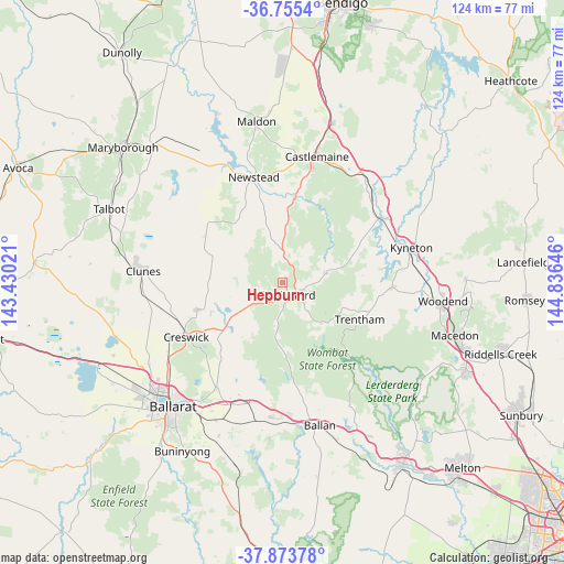
Hepburn GPS coordinates[2]
37° 19' 0.012" South, 144° 7' 59.988" East
| Map corner | latitude | longitude |
|---|---|---|
| Upper-left | -36.7554°, | 143.43021° |
| Center: | -37.31667°, | 144.13333° |
| Lower-right: | -37.87378°, | 144.83646° |
| Map W x H: | 124.4×124.4 km | = 77.3×77.3mi |
| max Lat: | -10.58257° ⇑82.1% North |
| Hepburn: | -37.31667° |
| min Lat: | ⇓17.9% South -43.31423° |
| min Long | Hepburn | max Long |
| 113.53327° | 144.13333° | 153.61246° |
| W 27.8%⇐ | ⇒72.2% E |
Elevation
Elevation of Hepburn is 499 m = 1637 ft, and this is 377 m = 1237 ft above average elevation for this country.
| Max E: |
1715 m = 5627 ft | 6.5% |
| Hepburn | 499 m 1637 ft | |
| Avg. | 122 m = 400 ft | |
Min E: |
-2 m = -7 ft | 93.5% |
See also: Australia elevation on elevation.city.
Geographical zone
Hepburn is located in South temperate zone (between Tropic of Capricorn and the Antarctic Circle). Distance of this Southern Tropic circle is 1543.3 km =959 mi to North.| Distance of | km | miles | from Hepburn |
|---|---|---|---|
| Equator | 4149.2 | 2578.2 | to North |
| Tropic Capricorn | 1543.3 | 959 | to North |
| Antarctic Circle | 3251.9 | 2020.6 | to South |
| South Pole | 5857.8 | 3639.9 | to South |


Nearby cities:
15 places around Hepburn: (largest is in red/bold)
• Campbells Creek
26.3 km =16.3 mi,  13°
13°
• Castlemaine
28.7 km =17.8 mi, 14°
• Chewton
28.4 km =17.6 mi,  22°
22°
• Clunes
30.8 km =19.1 mi,  274°
274°
• Creswick
24.2 km =15 mi,  240°
240°
• Daylesford
2.8 km =1.7 mi,  163°
163°
• Elphinstone
29.9 km =18.6 mi,  36°
36°
• Gordon
29.6 km =18.4 mi,  184°
184°
• Greendale
30.7 km =19.1 mi,  151°
151°
• Invermay
31.4 km =19.5 mi,  225°
225°
• Kyneton
29.3 km =18.2 mi,  74°
74°
• Malmsbury
26.4 km =16.4 mi,  57°
57°
• Newstead
24.2 km =15 mi,  345°
345°
• Trentham
18.5 km =11.5 mi,  115°
115°
• Tylden
24.1 km =15 mi,  92°
92°
Sources, notices
• [Note1] Compared only with cities in Australia existing in our database
• [Src1] Map data: © OpenStreetMap contributors (CC-BY-SA)
• [Src2] Other city data from geonames.org with taken over terms of usage.
• [Src3] Geographical zone / Annual Mean Temperature by Robert A. Rohde @ Wikipedia
