Bowning geodata
Bowning (New South Wales) is a populated place; located in Australia in Australia/Sydney (GMT+11) time zone. With population of 551 people, there are 4702 cities with bigger population in this country. Compared to other cities in Australia, 65.2% of cities are located further ↑North; 52.3% of cities are located further ←West and 94.3% of cities have lower elevation than Bowning. Note1


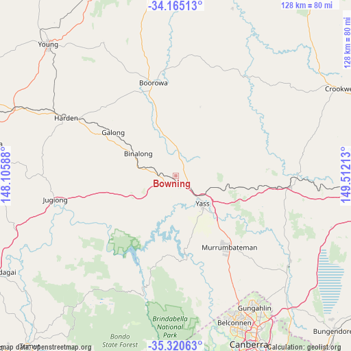
Bowning GPS coordinates[2]
34° 44' 41.64" South, 148° 48' 32.4" East
| Map corner | latitude | longitude |
|---|---|---|
| Upper-left | -34.16513°, | 148.10588° |
| Center: | -34.7449°, | 148.809° |
| Lower-right: | -35.32063°, | 149.51213° |
| Map W x H: | 128.5×128.5 km | = 79.8×79.8mi |
| max Lat: | -10.58257° ⇑65.2% North |
| Bowning: | -34.7449° |
| min Lat: | ⇓34.8% South -43.31423° |
| min Long | Bowning | max Long |
| 113.53327° | 148.809° | 153.61246° |
| W 52.3%⇐ | ⇒47.7% E |
Elevation
Elevation of Bowning is 560 m = 1837 ft, and this is 438 m = 1437 ft above average elevation for this country.
| Max E: |
1715 m = 5627 ft | 5.7% |
| Bowning | 560 m 1837 ft | |
| Avg. | 122 m = 400 ft | |
Min E: |
-2 m = -7 ft | 94.3% |
See also: Australia elevation on elevation.city.
Geographical zone
Bowning is located in South temperate zone (between Tropic of Capricorn and the Antarctic Circle). Distance of this Southern Tropic circle is 1257.4 km =781.3 mi to North.| Distance of | km | miles | from Bowning |
|---|---|---|---|
| Equator | 3863.3 | 2400.5 | to North |
| Tropic Capricorn | 1257.4 | 781.3 | to North |
| Antarctic Circle | 3537.9 | 2198.3 | to South |
| South Pole | 6143.8 | 3817.6 | to South |


Nearby cities:
15 places around Bowning: (largest is in red/bold)
• Binalong
17.9 km =11.1 mi,  297°
297°
• Bonner
55.3 km =34.4 mi,  147°
147°
• Boorowa
35.3 km =21.9 mi,  346°
346°
• Casey
53.7 km =33.4 mi, 150°
• Charnwood
54.6 km =33.9 mi,  157°
157°
• Dunlop
53.5 km =33.2 mi, 158°
• Fraser
54.1 km =33.6 mi, 156°
• Gundaroo
51.4 km =31.9 mi,  128°
128°
• Gunning
42 km =26.1 mi,  95°
95°
• Jacka
54.3 km =33.7 mi, 147°
• Macgregor
54.9 km =34.1 mi, 160°
• Murrumbateman
32.3 km =20.1 mi,  141°
141°
• Ngunnawal
55 km =34.2 mi, 149°
• Wallaroo
48.4 km =30.1 mi, 157°
• Yass
14.1 km =8.8 mi, 139°
Sources, notices
• [Note1] Compared only with cities in Australia existing in our database
• [Src1] Map data: © OpenStreetMap contributors (CC-BY-SA)
• [Src2] Other city data from geonames.org with taken over terms of usage.
• [Src3] Geographical zone / Annual Mean Temperature by Robert A. Rohde @ Wikipedia
