Binalong geodata
Binalong (New South Wales) is a populated place; located in Australia in Australia/Sydney (GMT+11) time zone. With population of 530 people, there are 4780 cities with bigger population in this country. Compared to other cities in Australia, 64.6% of cities are located further ↑North; 51.9% of cities are located further ←West and 93.1% of cities have lower elevation than Binalong. Note1


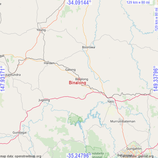
Binalong GPS coordinates[2]
34° 40' 18.192" South, 148° 38' 5.388" East
| Map corner | latitude | longitude |
|---|---|---|
| Upper-left | -34.09144°, | 147.93171° |
| Center: | -34.67172°, | 148.63483° |
| Lower-right: | -35.24796°, | 149.33796° |
| Map W x H: | 128.6×128.6 km | = 79.9×79.9mi |
| max Lat: | -10.58257° ⇑64.6% North |
| Binalong: | -34.67172° |
| min Lat: | ⇓35.4% South -43.31423° |
| min Long | Binalong | max Long |
| 113.53327° | 148.63483° | 153.61246° |
| W 51.9%⇐ | ⇒48.1% E |
Elevation
Elevation of Binalong is 478 m = 1568 ft, and this is 356 m = 1168 ft above average elevation for this country.
| Max E: |
1715 m = 5627 ft | 6.9% |
| Binalong | 478 m 1568 ft | |
| Avg. | 122 m = 400 ft | |
Min E: |
-2 m = -7 ft | 93.1% |
See also: Australia elevation on elevation.city.
Geographical zone
Binalong is located in South temperate zone (between Tropic of Capricorn and the Antarctic Circle). Distance of this Southern Tropic circle is 1249.2 km =776.2 mi to North.| Distance of | km | miles | from Binalong |
|---|---|---|---|
| Equator | 3855.1 | 2395.4 | to North |
| Tropic Capricorn | 1249.2 | 776.2 | to North |
| Antarctic Circle | 3546 | 2203.4 | to South |
| South Pole | 6151.9 | 3822.6 | to South |


Nearby cities:
15 places around Binalong: (largest is in red/bold)
• Boorowa
27.2 km =16.9 mi,  15°
15°
• Bowning
17.9 km =11.1 mi,  117°
117°
• Charnwood
69.1 km =42.9 mi,  148°
148°
• Cootamundra
55.6 km =34.5 mi,  273°
273°
• Dunlop
67.9 km =42.2 mi, 148°
• Fraser
68.9 km =42.8 mi, 147°
• Gundagai
65.2 km =40.5 mi,  228°
228°
• Gundaroo
69 km =42.9 mi,  125°
125°
• Gunning
59 km =36.7 mi,  102°
102°
• Macgregor
69 km =42.9 mi, 150°
• Murrumbateman
49.1 km =30.5 mi, 132°
• South Gundagai
66.8 km =41.5 mi, 227°
• Wallaroo
63.1 km =39.2 mi, 146°
• Yass
31.4 km =19.5 mi, 126°
• Young
50.2 km =31.2 mi,  322°
322°
Sources, notices
• [Note1] Compared only with cities in Australia existing in our database
• [Src1] Map data: © OpenStreetMap contributors (CC-BY-SA)
• [Src2] Other city data from geonames.org with taken over terms of usage.
• [Src3] Geographical zone / Annual Mean Temperature by Robert A. Rohde @ Wikipedia
