Boorowa geodata
Boorowa (New South Wales) is a populated place; located in Australia in Australia/Sydney (GMT+11) time zone. With population of 1,627 people, there are 3163 cities with bigger population in this country. Compared to other cities in Australia, 62.7% of cities are located further ↑North; 52.2% of cities are located further ←West and 93.3% of cities have lower elevation than Boorowa. Note1


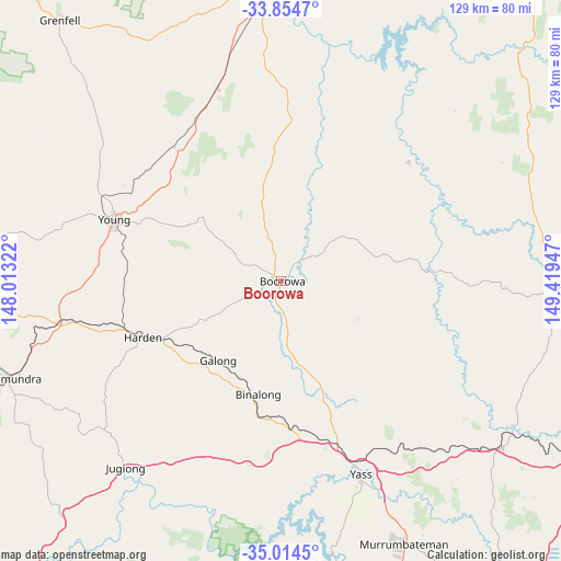
Boorowa GPS coordinates[2]
34° 26' 11.796" South, 148° 42' 58.824" East
| Map corner | latitude | longitude |
|---|---|---|
| Upper-left | -33.8547°, | 148.01322° |
| Center: | -34.43661°, | 148.71634° |
| Lower-right: | -35.0145°, | 149.41947° |
| Map W x H: | 129×129 km | = 80.2×80.2mi |
| max Lat: | -10.58257° ⇑62.7% North |
| Boorowa: | -34.43661° |
| min Lat: | ⇓37.3% South -43.31423° |
| min Long | Boorowa | max Long |
| 113.53327° | 148.71634° | 153.61246° |
| W 52.2%⇐ | ⇒47.8% E |
Elevation
Elevation of Boorowa is 487 m = 1598 ft, and this is 365 m = 1198 ft above average elevation for this country.
| Max E: |
1715 m = 5627 ft | 6.7% |
| Boorowa | 487 m 1598 ft | |
| Avg. | 122 m = 400 ft | |
Min E: |
-2 m = -7 ft | 93.3% |
See also: Australia elevation on elevation.city.
Geographical zone
Boorowa is located in South temperate zone (between Tropic of Capricorn and the Antarctic Circle). Distance of this Southern Tropic circle is 1223.1 km =760 mi to North.| Distance of | km | miles | from Boorowa |
|---|---|---|---|
| Equator | 3829 | 2379.2 | to North |
| Tropic Capricorn | 1223.1 | 760 | to North |
| Antarctic Circle | 3572.2 | 2219.7 | to South |
| South Pole | 6178.1 | 3838.9 | to South |


Nearby cities:
15 places around Boorowa: (largest is in red/bold)
• Binalong
27.2 km =16.9 mi,  195°
195°
• Bowning
35.3 km =21.9 mi,  166°
166°
• Casey
88.3 km =54.9 mi,  156°
156°
• Cootamundra
67 km =41.6 mi,  250°
250°
• Cowra
66.9 km =41.6 mi,  358°
358°
• Crookwell
69.3 km =43.1 mi,  92°
92°
• Grenfell
78.7 km =48.9 mi,  319°
319°
• Gundaroo
82.3 km =51.1 mi,  143°
143°
• Gunning
63.3 km =39.3 mi,  127°
127°
• Jacka
88.5 km =55 mi,  154°
154°
• Murrumbateman
66.1 km =41.1 mi, 154°
• Wallaroo
83.5 km =51.9 mi, 161°
• Woodstock
77.9 km =48.4 mi,  9°
9°
• Yass
48.3 km =30 mi, 158°
• Young
40.5 km =25.2 mi,  289°
289°
Sources, notices
• [Note1] Compared only with cities in Australia existing in our database
• [Src1] Map data: © OpenStreetMap contributors (CC-BY-SA)
• [Src2] Other city data from geonames.org with taken over terms of usage.
• [Src3] Geographical zone / Annual Mean Temperature by Robert A. Rohde @ Wikipedia
