Narrabri geodata
Narrabri (New South Wales) is a populated place; located in Australia in Australia/Sydney (GMT+11) time zone. With population of 7,866 people, there are 851 cities with bigger population in this country. Compared to other cities in Australia, 71.8% of cities are located further ↓South; 56.6% of cities are located further ←West and 82.7% of cities have lower elevation than Narrabri. Note1


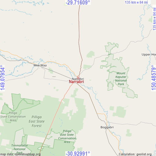
Narrabri GPS coordinates[2]
30° 19' 29.568" South, 149° 46' 57.576" East
| Map corner | latitude | longitude |
|---|---|---|
| Upper-left | -29.71609°, | 149.07954° |
| Center: | -30.32488°, | 149.78266° |
| Lower-right: | -30.92991°, | 150.48579° |
| Map W x H: | 135×135 km | = 83.9×83.9mi |
| max Lat: | -10.58257° ⇑28.2% North |
| Narrabri: | -30.32488° |
| min Lat: | ⇓71.8% South -43.31423° |
| min Long | Narrabri | max Long |
| 113.53327° | 149.78266° | 153.61246° |
| W 56.6%⇐ | ⇒43.4% E |
Elevation
Elevation of Narrabri is 214 m = 702 ft, and this is 92 m = 302 ft above average elevation for this country.
| Max E: |
1715 m = 5627 ft | 17.3% |
| Narrabri | 214 m 702 ft | |
| Avg. | 122 m = 400 ft | |
Min E: |
-2 m = -7 ft | 82.7% |
See also: Australia elevation on elevation.city.
Geographical zone
Narrabri is located in South temperate zone (between Tropic of Capricorn and the Antarctic Circle). Distance of this Southern Tropic circle is 765.9 km =475.9 mi to North.| Distance of | km | miles | from Narrabri |
|---|---|---|---|
| Equator | 3371.8 | 2095.1 | to North |
| Tropic Capricorn | 765.9 | 475.9 | to North |
| Antarctic Circle | 4029.4 | 2503.8 | to South |
| South Pole | 6635.3 | 4123 | to South |


Nearby cities:
15 places around Narrabri: (largest is in red/bold)
• Attunga
122.1 km =75.9 mi,  123°
123°
• Baradine
97.3 km =60.5 mi,  224°
224°
• Barraba
79.6 km =49.5 mi,  94°
94°
• Bingara
91.3 km =56.7 mi,  56°
56°
• Blair Athol
53.9 km =33.5 mi,  132°
132°
• Boggabri
49.4 km =30.7 mi,  149°
149°
• Bundarra
125.4 km =77.9 mi,  82°
82°
• Coonabarabran
116.3 km =72.3 mi,  204°
204°
• Curlewis
99.5 km =61.8 mi, 152°
• Delungra
125.4 km =77.9 mi,  53°
53°
• Gunnedah
85.9 km =53.4 mi, 148°
• Manilla
101.3 km =62.9 mi, 117°
• Moree
96 km =59.7 mi,  3°
3°
• Warialda
115.7 km =71.9 mi,  41°
41°
• Wee Waa
34.6 km =21.5 mi,  288°
288°
Sources, notices
• [Note1] Compared only with cities in Australia existing in our database
• [Src1] Map data: © OpenStreetMap contributors (CC-BY-SA)
• [Src2] Other city data from geonames.org with taken over terms of usage.
• [Src3] Geographical zone / Annual Mean Temperature by Robert A. Rohde @ Wikipedia
