Bloomsbury geodata
Bloomsbury (Queensland) is a populated place; located in Australia in Australia/Brisbane (GMT+10) time zone. With population of 615 people, there are 4532 cities with bigger population in this country. Compared to other cities in Australia, 94.1% of cities are located further ↓South; 51.8% of cities are located further ←West and 51.1% of cities have lower elevation than Bloomsbury. Note1


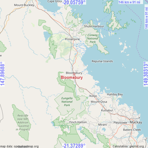
Bloomsbury GPS coordinates[2]
20° 43' 0.012" South, 148° 36' 0" East
| Map corner | latitude | longitude |
|---|---|---|
| Upper-left | -20.05759°, | 147.89688° |
| Center: | -20.71667°, | 148.6° |
| Lower-right: | -21.37289°, | 149.30313° |
| Map W x H: | 146.2×146.2 km | = 90.8×90.8mi |
| max Lat: | -10.58257° ⇑5.9% North |
| Bloomsbury: | -20.71667° |
| min Lat: | ⇓94.1% South -43.31423° |
| min Long | Bloomsbury | max Long |
| 113.53327° | 148.6° | 153.61246° |
| W 51.8%⇐ | ⇒48.2% E |
Elevation
Elevation of Bloomsbury is 47 m = 154 ft, and this is 75 m = 246 ft below average elevation for this country.
| Max E: |
1715 m = 5627 ft | 48.9% |
| Avg. | 122 m = 400 ft | |
| Bloomsbury | 47 m = 154 ft | |
Min E: |
-2 m = -7 ft | 51.1% |
See also: Australia elevation on elevation.city.
Geographical zone
Bloomsbury is located in South Torrid zone (between Equator and Tropic of Capricorn). Distance of this Southern Tropic circle is 302.4 km =187.9 mi to South.| Distance of | km | miles | from Bloomsbury |
|---|---|---|---|
| Equator | 2303.5 | 1431.3 | to North |
| Tropic Capricorn | 302.4 | 187.9 | to South |
| Antarctic Circle | 5097.7 | 3167.6 | to South |
| South Pole | 7703.6 | 4786.8 | to South |


Nearby cities:
15 places around Bloomsbury: (largest is in red/bold)
• Airlie Beach
51.4 km =31.9 mi,  13°
13°
• Cannon Valley
44.7 km =27.8 mi, 6°
• Cannonvale
50 km =31.1 mi, 11°
• Finch Hatton
47.2 km =29.3 mi,  176°
176°
• Habana
61.3 km =38.1 mi,  125°
125°
• Hampden
52.1 km =32.4 mi,  138°
138°
• Jubilee Pocket
49.5 km =30.8 mi,  15°
15°
• Kuttabul
47 km =29.2 mi, 138°
• Marian
59.3 km =36.8 mi, 143°
• Mirani
56 km =34.8 mi,  150°
150°
• Proserpine
35.1 km =21.8 mi,  356°
356°
• Red Hill
45.7 km =28.4 mi,  346°
346°
• Seaforth
43.4 km =27 mi,  118°
118°
• Strathdickie
42.7 km =26.5 mi,  2°
2°
• The Leap
59.5 km =37 mi, 133°
Sources, notices
• [Note1] Compared only with cities in Australia existing in our database
• [Src1] Map data: © OpenStreetMap contributors (CC-BY-SA)
• [Src2] Other city data from geonames.org with taken over terms of usage.
• [Src3] Geographical zone / Annual Mean Temperature by Robert A. Rohde @ Wikipedia
