Strathdickie geodata
Strathdickie (Queensland) is a populated place; located in Australia in Australia/Brisbane (GMT+10) time zone. With population of 855 people, there are 4054 cities with bigger population in this country. Compared to other cities in Australia, 94.3% of cities are located further ↓South; 51.9% of cities are located further ←West and 51.1% of cities have lower elevation than Strathdickie. Note1


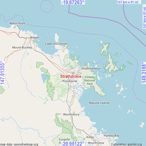
Strathdickie GPS coordinates[2]
20° 19' 59.988" South, 148° 37' 0.012" East
| Map corner | latitude | longitude |
|---|---|---|
| Upper-left | -19.67263°, | 147.91355° |
| Center: | -20.33333°, | 148.61667° |
| Lower-right: | -20.99122°, | 149.3198° |
| Map W x H: | 146.6×146.6 km | = 91.1×91.1mi |
| max Lat: | -10.58257° ⇑5.7% North |
| Strathdickie: | -20.33333° |
| min Lat: | ⇓94.3% South -43.31423° |
| min Long | Strathdickie | max Long |
| 113.53327° | 148.61667° | 153.61246° |
| W 51.9%⇐ | ⇒48.1% E |
Elevation
Elevation of Strathdickie is 47 m = 154 ft, and this is 75 m = 246 ft below average elevation for this country.
| Max E: |
1715 m = 5627 ft | 48.9% |
| Avg. | 122 m = 400 ft | |
| Strathdickie | 47 m = 154 ft | |
Min E: |
-2 m = -7 ft | 51.1% |
See also: Australia elevation on elevation.city.
Geographical zone
Strathdickie is located in South Torrid zone (between Equator and Tropic of Capricorn). Distance of this Southern Tropic circle is 345.1 km =214.4 mi to South.| Distance of | km | miles | from Strathdickie |
|---|---|---|---|
| Equator | 2260.9 | 1404.9 | to North |
| Tropic Capricorn | 345.1 | 214.4 | to South |
| Antarctic Circle | 5140.3 | 3194 | to South |
| South Pole | 7746.2 | 4813.3 | to South |


Nearby cities:
15 places around Strathdickie: (largest is in red/bold)
• Airlie Beach
12.6 km =7.8 mi,  54°
54°
• Bloomsbury
42.7 km =26.5 mi,  182°
182°
• Bowen
52.4 km =32.6 mi,  312°
312°
• Cannon Valley
4.1 km =2.5 mi,  64°
64°
• Cannonvale
10.5 km =6.5 mi, 53°
• Collinsville
84.1 km =52.3 mi,  253°
253°
• Finch Hatton
89.7 km =55.7 mi, 179°
• Habana
91.7 km =57 mi,  148°
148°
• Hampden
87.9 km =54.6 mi,  158°
158°
• Jubilee Pocket
12.8 km =8 mi,  66°
66°
• Kuttabul
83.2 km =51.7 mi, 159°
• Proserpine
8.4 km =5.2 mi,  206°
206°
• Red Hill
12.3 km =7.6 mi,  278°
278°
• Seaforth
72.9 km =45.3 mi, 149°
• Whitsundays
39 km =24.2 mi, 52°
Sources, notices
• [Note1] Compared only with cities in Australia existing in our database
• [Src1] Map data: © OpenStreetMap contributors (CC-BY-SA)
• [Src2] Other city data from geonames.org with taken over terms of usage.
• [Src3] Geographical zone / Annual Mean Temperature by Robert A. Rohde @ Wikipedia
