Cannonvale geodata
Cannonvale (Queensland) is a populated place; located in Australia in Australia/Brisbane (GMT+10) time zone. With population of 6,107 people, there are 1180 cities with bigger population in this country. Compared to other cities in Australia, 94.4% of cities are located further ↓South; 52.1% of cities are located further ←West and 85% of cities have higher elevation than Cannonvale. Note1


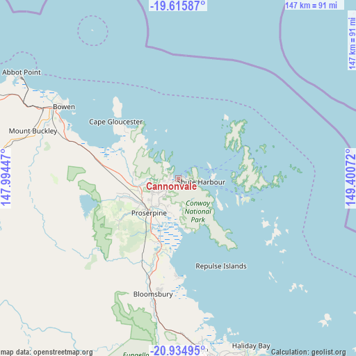
Cannonvale GPS coordinates[2]
20° 16' 36.516" South, 148° 41' 51.324" East
| Map corner | latitude | longitude |
|---|---|---|
| Upper-left | -19.61587°, | 147.99447° |
| Center: | -20.27681°, | 148.69759° |
| Lower-right: | -20.93495°, | 149.40072° |
| Map W x H: | 146.7×146.7 km | = 91.2×91.2mi |
| max Lat: | -10.58257° ⇑5.6% North |
| Cannonvale: | -20.27681° |
| min Lat: | ⇓94.4% South -43.31423° |
| min Long | Cannonvale | max Long |
| 113.53327° | 148.69759° | 153.61246° |
| W 52.1%⇐ | ⇒47.9% E |
Elevation
Elevation of Cannonvale is 12 m = 39 ft, and this is 110 m = 361 ft below average elevation for this country.
| Max E: |
1715 m = 5627 ft | 85% |
| Avg. | 122 m = 400 ft | |
| Cannonvale | 12 m = 39 ft | |
Min E: |
-2 m = -7 ft | 15% |
See also: Australia elevation on elevation.city.
Geographical zone
Cannonvale is located in South Torrid zone (between Equator and Tropic of Capricorn). Distance of this Southern Tropic circle is 351.3 km =218.3 mi to South.| Distance of | km | miles | from Cannonvale |
|---|---|---|---|
| Equator | 2254.6 | 1400.9 | to North |
| Tropic Capricorn | 351.3 | 218.3 | to South |
| Antarctic Circle | 5146.6 | 3197.9 | to South |
| South Pole | 7752.5 | 4817.2 | to South |


Nearby cities:
15 places around Cannonvale: (largest is in red/bold)
• Airlie Beach
2.1 km =1.3 mi,  59°
59°
• Bloomsbury
50 km =31.1 mi,  191°
191°
• Bowen
55.3 km =34.4 mi,  301°
301°
• Cannon Valley
6.5 km =4 mi,  226°
226°
• Collinsville
94.1 km =58.5 mi,  251°
251°
• Habana
93.2 km =57.9 mi,  154°
154°
• Hampden
91.2 km =56.7 mi,  164°
164°
• Jubilee Pocket
3.5 km =2.2 mi,  110°
110°
• Kuttabul
86.7 km =53.9 mi,  165°
165°
• Proserpine
18.5 km =11.5 mi,  221°
221°
• Red Hill
21.1 km =13.1 mi,  257°
257°
• Seaforth
74.8 km =46.5 mi, 157°
• Shoal Point
93.8 km =58.3 mi, 149°
• Strathdickie
10.5 km =6.5 mi, 233°
• Whitsundays
28.5 km =17.7 mi,  52°
52°
Sources, notices
• [Note1] Compared only with cities in Australia existing in our database
• [Src1] Map data: © OpenStreetMap contributors (CC-BY-SA)
• [Src2] Other city data from geonames.org with taken over terms of usage.
• [Src3] Geographical zone / Annual Mean Temperature by Robert A. Rohde @ Wikipedia
