Red Hill geodata
Red Hill (Queensland) is a populated place; located in Australia in Australia/Brisbane (GMT+10) time zone. With population of 5,406 people, there are 1374 cities with bigger population in this country. Compared to other cities in Australia, 94.3% of cities are located further ↓South; 51.7% of cities are located further ←West and 60% of cities have higher elevation than Red Hill. Note1


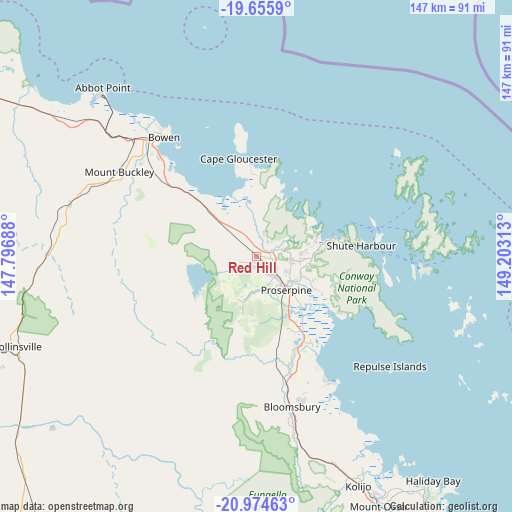
Red Hill GPS coordinates[2]
20° 19' 0.012" South, 148° 30' 0" East
| Map corner | latitude | longitude |
|---|---|---|
| Upper-left | -19.6559°, | 147.79688° |
| Center: | -20.31667°, | 148.5° |
| Lower-right: | -20.97463°, | 149.20313° |
| Map W x H: | 146.6×146.6 km | = 91.1×91.1mi |
| max Lat: | -10.58257° ⇑5.7% North |
| Red Hill: | -20.31667° |
| min Lat: | ⇓94.3% South -43.31423° |
| min Long | Red Hill | max Long |
| 113.53327° | 148.5° | 153.61246° |
| W 51.7%⇐ | ⇒48.3% E |
Elevation
Elevation of Red Hill is 32 m = 105 ft, and this is 90 m = 295 ft below average elevation for this country.
| Max E: |
1715 m = 5627 ft | 60% |
| Avg. | 122 m = 400 ft | |
| Red Hill | 32 m = 105 ft | |
Min E: |
-2 m = -7 ft | 40% |
See also: Australia elevation on elevation.city.
Geographical zone
Red Hill is located in South Torrid zone (between Equator and Tropic of Capricorn). Distance of this Southern Tropic circle is 346.9 km =215.6 mi to South.| Distance of | km | miles | from Red Hill |
|---|---|---|---|
| Equator | 2259 | 1403.7 | to North |
| Tropic Capricorn | 346.9 | 215.6 | to South |
| Antarctic Circle | 5142.2 | 3195.2 | to South |
| South Pole | 7748.1 | 4814.4 | to South |


Nearby cities:
15 places around Red Hill: (largest is in red/bold)
• Airlie Beach
23 km =14.3 mi,  76°
76°
• Bloomsbury
45.7 km =28.4 mi,  166°
166°
• Bowen
42.8 km =26.6 mi,  321°
321°
• Cannon Valley
15.9 km =9.9 mi,  90°
90°
• Cannonvale
21.1 km =13.1 mi, 77°
• Collinsville
73.2 km =45.5 mi,  249°
249°
• Finch Hatton
92.6 km =57.5 mi, 171°
• Habana
100.2 km =62.3 mi,  142°
142°
• Hampden
94.8 km =58.9 mi,  151°
151°
• Jubilee Pocket
24.1 km =15 mi, 82°
• Kuttabul
89.9 km =55.9 mi, 152°
• Proserpine
12.6 km =7.8 mi, 138°
• Seaforth
81.1 km =50.4 mi, 143°
• Strathdickie
12.3 km =7.6 mi,  98°
98°
• Whitsundays
48.4 km =30.1 mi,  63°
63°
Sources, notices
• [Note1] Compared only with cities in Australia existing in our database
• [Src1] Map data: © OpenStreetMap contributors (CC-BY-SA)
• [Src2] Other city data from geonames.org with taken over terms of usage.
• [Src3] Geographical zone / Annual Mean Temperature by Robert A. Rohde @ Wikipedia
