Bauple geodata
Bauple (Queensland) is a populated place; located in Australia in Australia/Brisbane (GMT+10) time zone. With population of 622 people, there are 4512 cities with bigger population in this country. Compared to other cities in Australia, 88.7% of cities are located further ↓South; 85.2% of cities are located further ←West and 64.6% of cities have lower elevation than Bauple. Note1


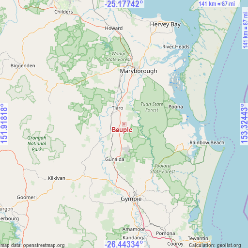
Bauple GPS coordinates[2]
25° 48' 43.452" South, 152° 37' 16.68" East
| Map corner | latitude | longitude |
|---|---|---|
| Upper-left | -25.17742°, | 151.91818° |
| Center: | -25.81207°, | 152.6213° |
| Lower-right: | -26.44334°, | 153.32443° |
| Map W x H: | 140.8×140.8 km | = 87.5×87.5mi |
| max Lat: | -10.58257° ⇑11.3% North |
| Bauple: | -25.81207° |
| min Lat: | ⇓88.7% South -43.31423° |
| min Long | Bauple | max Long |
| 113.53327° | 152.6213° | 153.61246° |
| W 85.2%⇐ | ⇒14.8% E |
Elevation
Elevation of Bauple is 79 m = 259 ft, and this is 43 m = 141 ft below average elevation for this country.
| Max E: |
1715 m = 5627 ft | 35.4% |
| Avg. | 122 m = 400 ft | |
| Bauple | 79 m = 259 ft | |
Min E: |
-2 m = -7 ft | 64.6% |
See also: Australia elevation on elevation.city.
Geographical zone
Bauple is located in South temperate zone (between Tropic of Capricorn and the Antarctic Circle). Distance of this Southern Tropic circle is 264.1 km =164.1 mi to North.| Distance of | km | miles | from Bauple |
|---|---|---|---|
| Equator | 2870 | 1783.3 | to North |
| Tropic Capricorn | 264.1 | 164.1 | to North |
| Antarctic Circle | 4531.1 | 2815.5 | to South |
| South Pole | 7137 | 4434.7 | to South |


Nearby cities:
15 places around Bauple: (largest is in red/bold)
• Aldershot
39 km =24.2 mi,  6°
6°
• Araluen
38.5 km =23.9 mi,  175°
175°
• Chatsworth
36.9 km =22.9 mi, 180°
• Curra
28.6 km =17.8 mi,  187°
187°
• Granville
31.8 km =19.8 mi,  20°
20°
• Maryborough
31.3 km =19.4 mi, 15°
• Maryborough West
34.4 km =21.4 mi, 7°
• Oakhurst
33.3 km =20.7 mi,  2°
2°
• Poona
30.8 km =19.1 mi,  69°
69°
• Tamaree
36.1 km =22.4 mi,  173°
173°
• Tiaro
10.3 km =6.4 mi,  337°
337°
• Tin Can Bay
40 km =24.9 mi,  107°
107°
• Tinana
29.3 km =18.2 mi, 8°
• Veteran
39.2 km =24.4 mi, 169°
• Victory Heights
40.6 km =25.2 mi, 170°
Sources, notices
• [Note1] Compared only with cities in Australia existing in our database
• [Src1] Map data: © OpenStreetMap contributors (CC-BY-SA)
• [Src2] Other city data from geonames.org with taken over terms of usage.
• [Src3] Geographical zone / Annual Mean Temperature by Robert A. Rohde @ Wikipedia
