Mullaloo geodata
Mullaloo (Western Australia) is a populated locality; located in Australia in Australia/Perth (GMT+8) time zone. With population of 5,794 people, there are 1258 cities with bigger population in this country. Compared to other cities in Australia, 68.3% of cities are located further ↓South; 97.7% of cities are located further →East and 79% of cities have higher elevation than Mullaloo. Note1


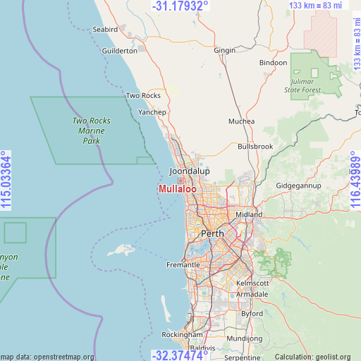
Mullaloo GPS coordinates[2]
31° 46' 44.256" South, 115° 44' 12.336" East
| Map corner | latitude | longitude |
|---|---|---|
| Upper-left | -31.17932°, | 115.03364° |
| Center: | -31.77896°, | 115.73676° |
| Lower-right: | -32.37474°, | 116.43989° |
| Map W x H: | 132.9×132.9 km | = 82.6×82.6mi |
| max Lat: | -10.58257° ⇑31.7% North |
| Mullaloo: | -31.77896° |
| min Lat: | ⇓68.3% South -43.31423° |
| min Long | Mullaloo | max Long |
| 113.53327° | 115.73676° | 153.61246° |
| W 2.3%⇐ | ⇒97.7% E |
Elevation
Elevation of Mullaloo is 16 m = 52 ft, and this is 106 m = 348 ft below average elevation for this country.
| Max E: |
1715 m = 5627 ft | 79% |
| Avg. | 122 m = 400 ft | |
| Mullaloo | 16 m = 52 ft | |
Min E: |
-2 m = -7 ft | 21% |
See also: Australia elevation on elevation.city.
Geographical zone
Mullaloo is located in South temperate zone (between Tropic of Capricorn and the Antarctic Circle). Distance of this Southern Tropic circle is 927.6 km =576.4 mi to North.| Distance of | km | miles | from Mullaloo |
|---|---|---|---|
| Equator | 3533.5 | 2195.6 | to North |
| Tropic Capricorn | 927.6 | 576.4 | to North |
| Antarctic Circle | 3867.7 | 2403.3 | to South |
| South Pole | 6473.6 | 4022.5 | to South |


Nearby cities:
15 places around Mullaloo: (largest is in red/bold)
• Beldon
2.5 km =1.6 mi,  78°
78°
• Connolly
3.6 km =2.2 mi,  21°
21°
• Craigie
3.3 km =2.1 mi,  106°
106°
• Currambine
5.2 km =3.2 mi,  11°
11°
• Edgewater
4.6 km =2.9 mi,  70°
70°
• Heathridge
2.8 km =1.7 mi,  48°
48°
• Hillarys
3.1 km =1.9 mi,  173°
173°
• Iluka
4.9 km =3 mi,  353°
353°
• Joondalup
4.9 km =3 mi,  37°
37°
• Kallaroo
2 km =1.2 mi,  131°
131°
• Kinross
6.7 km =4.2 mi,  1°
1°
• Ocean Reef
2.3 km =1.4 mi,  358°
358°
• Padbury
4.3 km =2.7 mi,  135°
135°
• Sorrento
5.4 km =3.4 mi,  163°
163°
• Woodvale
5.8 km =3.6 mi,  101°
101°
Sources, notices
• [Note1] Compared only with cities in Australia existing in our database
• [Src1] Map data: © OpenStreetMap contributors (CC-BY-SA)
• [Src2] Other city data from geonames.org with taken over terms of usage.
• [Src3] Geographical zone / Annual Mean Temperature by Robert A. Rohde @ Wikipedia
