Tamborine Mountain geodata
Tamborine Mountain (Queensland) is a populated place; located in Australia in Australia/Brisbane (GMT+10) time zone. With population of 7,675 people, there are 878 cities with bigger population in this country. Compared to other cities in Australia, 76.3% of cities are located further ↓South; 96.7% of cities are located further ←West and 93.8% of cities have lower elevation than Tamborine Mountain. Note1


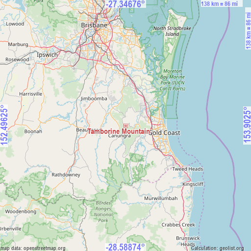
Tamborine Mountain GPS coordinates[2]
27° 58' 10.344" South, 153° 11' 57.732" East
| Map corner | latitude | longitude |
|---|---|---|
| Upper-left | -27.34676°, | 152.49625° |
| Center: | -27.96954°, | 153.19937° |
| Lower-right: | -28.58874°, | 153.9025° |
| Map W x H: | 138.1×138.1 km | = 85.8×85.8mi |
| max Lat: | -10.58257° ⇑23.7% North |
| Tamborine Mountain: | -27.96954° |
| min Lat: | ⇓76.3% South -43.31423° |
| min Long | Tamborine Mount | max Long |
| 113.53327° | 153.19937° | 153.61246° |
| W 96.7%⇐ | ⇒3.3% E |
Elevation
Elevation of Tamborine Mountain is 525 m = 1722 ft, and this is 403 m = 1322 ft above average elevation for this country.
| Max E: |
1715 m = 5627 ft | 6.2% |
| Tamborine Mountain | 525 m 1722 ft | |
| Avg. | 122 m = 400 ft | |
Min E: |
-2 m = -7 ft | 93.8% |
See also: Australia elevation on elevation.city.
Geographical zone
Tamborine Mountain is located in South temperate zone (between Tropic of Capricorn and the Antarctic Circle). Distance of this Southern Tropic circle is 504 km =313.2 mi to North.| Distance of | km | miles | from Tamborine Mountain |
|---|---|---|---|
| Equator | 3109.9 | 1932.4 | to North |
| Tropic Capricorn | 504 | 313.2 | to North |
| Antarctic Circle | 4291.3 | 2666.5 | to South |
| South Pole | 6897.1 | 4285.7 | to South |


Nearby cities:
15 places around Tamborine Mountain: (largest is in red/bold)
• Advancetown
12.7 km =7.9 mi,  148°
148°
• Boyland
6.8 km =4.2 mi,  288°
288°
• Canungra
6.2 km =3.9 mi,  212°
212°
• Cedar Creek
12 km =7.5 mi,  0°
0°
• Clagiraba
5 km =3.1 mi,  122°
122°
• Gilston
12.2 km =7.6 mi,  125°
125°
• Guanaba
5.3 km =3.3 mi,  48°
48°
• Lower Beechmont
9.8 km =6.1 mi, 152°
• Maudsland
7 km =4.3 mi,  71°
71°
• Mount Nathan
7.2 km =4.5 mi,  85°
85°
• Pacific Pines
11.8 km =7.3 mi, 73°
• Tamborine
11.6 km =7.2 mi,  325°
325°
• Upper Coomera
13.4 km =8.3 mi,  39°
39°
• Witheren
7.8 km =4.8 mi,  185°
185°
• Wongawallan
10.8 km =6.7 mi,  15°
15°
Sources, notices
• [Note1] Compared only with cities in Australia existing in our database
• [Src1] Map data: © OpenStreetMap contributors (CC-BY-SA)
• [Src2] Other city data from geonames.org with taken over terms of usage.
• [Src3] Geographical zone / Annual Mean Temperature by Robert A. Rohde @ Wikipedia
