Gilston geodata
Gilston (Queensland) is a section of populated place; located in Australia in Australia/Brisbane (GMT+10) time zone. With population of 2,413 people, there are 2625 cities with bigger population in this country. Compared to other cities in Australia, 75.9% of cities are located further ↓South; 97.6% of cities are located further ←West and 56.9% of cities have higher elevation than Gilston. Note1


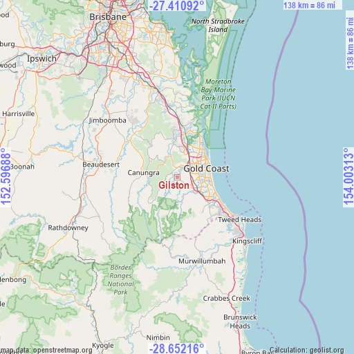
Gilston GPS coordinates[2]
28° 1' 59.988" South, 153° 18' 0" East
| Map corner | latitude | longitude |
|---|---|---|
| Upper-left | -27.41092°, | 152.59688° |
| Center: | -28.03333°, | 153.3° |
| Lower-right: | -28.65216°, | 154.00313° |
| Map W x H: | 138×138 km | = 85.7×85.7mi |
| max Lat: | -10.58257° ⇑24.1% North |
| Gilston: | -28.03333° |
| min Lat: | ⇓75.9% South -43.31423° |
| min Long | Gilston | max Long |
| 113.53327° | 153.3° | 153.61246° |
| W 97.6%⇐ | ⇒2.4% E |
Elevation
Elevation of Gilston is 36 m = 118 ft, and this is 86 m = 282 ft below average elevation for this country.
| Max E: |
1715 m = 5627 ft | 56.9% |
| Avg. | 122 m = 400 ft | |
| Gilston | 36 m = 118 ft | |
Min E: |
-2 m = -7 ft | 43.1% |
See also: Australia elevation on elevation.city.
Geographical zone
Gilston is located in South temperate zone (between Tropic of Capricorn and the Antarctic Circle). Distance of this Southern Tropic circle is 511.1 km =317.6 mi to North.| Distance of | km | miles | from Gilston |
|---|---|---|---|
| Equator | 3117 | 1936.8 | to North |
| Tropic Capricorn | 511.1 | 317.6 | to North |
| Antarctic Circle | 4284.2 | 2662.1 | to South |
| South Pole | 6890 | 4281.2 | to South |


Nearby cities:
15 places around Gilston: (largest is in red/bold)
• Advancetown
4.9 km =3 mi,  221°
221°
• Ashmore
9 km =5.6 mi,  56°
56°
• Benowa
8.9 km =5.5 mi,  71°
71°
• Carrara
6.6 km =4.1 mi,  78°
78°
• Clagiraba
7.2 km =4.5 mi,  307°
307°
• Gaven
9.2 km =5.7 mi,  21°
21°
• Highland Park
3.9 km =2.4 mi, 56°
• Lower Beechmont
5.6 km =3.5 mi,  253°
253°
• Merrimac
7.4 km =4.6 mi,  105°
105°
• Molendinar
8.9 km =5.5 mi,  42°
42°
• Mount Nathan
8.2 km =5.1 mi,  340°
340°
• Mudgeeraba
8.6 km =5.3 mi,  130°
130°
• Nerang
6 km =3.7 mi, 36°
• Tallai
4.3 km =2.7 mi,  143°
143°
• Worongary
5.2 km =3.2 mi, 110°
Sources, notices
• [Note1] Compared only with cities in Australia existing in our database
• [Src1] Map data: © OpenStreetMap contributors (CC-BY-SA)
• [Src2] Other city data from geonames.org with taken over terms of usage.
• [Src3] Geographical zone / Annual Mean Temperature by Robert A. Rohde @ Wikipedia
