Canungra geodata
Canungra (Queensland) is a populated place; located in Australia in Australia/Brisbane (GMT+10) time zone. With population of 1,254 people, there are 3516 cities with bigger population in this country. Compared to other cities in Australia, 76% of cities are located further ↓South; 96.2% of cities are located further ←West and 69% of cities have lower elevation than Canungra. Note1


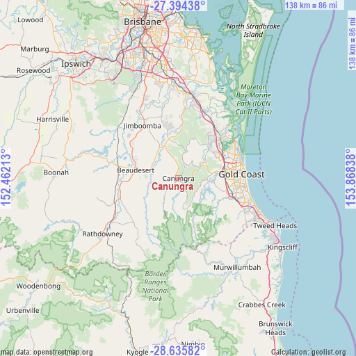
Canungra GPS coordinates[2]
28° 1' 0.804" South, 153° 9' 54.9" East
| Map corner | latitude | longitude |
|---|---|---|
| Upper-left | -27.39438°, | 152.46213° |
| Center: | -28.01689°, | 153.16525° |
| Lower-right: | -28.63582°, | 153.86838° |
| Map W x H: | 138×138 km | = 85.7×85.7mi |
| max Lat: | -10.58257° ⇑24% North |
| Canungra: | -28.01689° |
| min Lat: | ⇓76% South -43.31423° |
| min Long | Canungra | max Long |
| 113.53327° | 153.16525° | 153.61246° |
| W 96.2%⇐ | ⇒3.8% E |
Elevation
Elevation of Canungra is 96 m = 315 ft, and this is 26 m = 85 ft below average elevation for this country.
| Max E: |
1715 m = 5627 ft | 31% |
| Avg. | 122 m = 400 ft | |
| Canungra | 96 m = 315 ft | |
Min E: |
-2 m = -7 ft | 69% |
See also: Australia elevation on elevation.city.
Geographical zone
Canungra is located in South temperate zone (between Tropic of Capricorn and the Antarctic Circle). Distance of this Southern Tropic circle is 509.3 km =316.5 mi to North.| Distance of | km | miles | from Canungra |
|---|---|---|---|
| Equator | 3115.2 | 1935.7 | to North |
| Tropic Capricorn | 509.3 | 316.5 | to North |
| Antarctic Circle | 4286 | 2663.2 | to South |
| South Pole | 6891.9 | 4282.4 | to South |


Nearby cities:
15 places around Canungra: (largest is in red/bold)
• Advancetown
11.4 km =7.1 mi,  119°
119°
• Beechmont
11.9 km =7.4 mi,  167°
167°
• Boyland
8.1 km =5 mi,  337°
337°
• Clagiraba
8 km =5 mi,  71°
71°
• Gilston
13.4 km =8.3 mi,  97°
97°
• Guanaba
11.4 km =7.1 mi,  39°
39°
• Highland Park
16.5 km =10.3 mi,  88°
88°
• Lower Beechmont
8.6 km =5.3 mi,  113°
113°
• Maudsland
12.4 km =7.7 mi,  53°
53°
• Mount Nathan
12 km =7.5 mi,  60°
60°
• Mundoolun
16 km =9.9 mi,  324°
324°
• Tallai
16.6 km =10.3 mi, 108°
• Tamborine
15.2 km =9.4 mi,  348°
348°
• Tamborine Mountain
6.2 km =3.9 mi,  32°
32°
• Witheren
3.6 km =2.2 mi,  133°
133°
Sources, notices
• [Note1] Compared only with cities in Australia existing in our database
• [Src1] Map data: © OpenStreetMap contributors (CC-BY-SA)
• [Src2] Other city data from geonames.org with taken over terms of usage.
• [Src3] Geographical zone / Annual Mean Temperature by Robert A. Rohde @ Wikipedia
