Shoalhaven Heads geodata
Shoalhaven Heads (New South Wales) is a populated place; located in Australia in Australia/Sydney (GMT+11) time zone. With population of 2,987 people, there are 2256 cities with bigger population in this country. Compared to other cities in Australia, 66.7% of cities are located further ↑North; 61.6% of cities are located further ←West and 90.1% of cities have higher elevation than Shoalhaven Heads. Note1


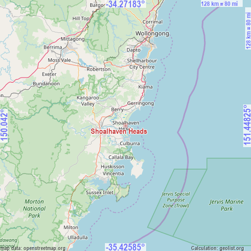
Shoalhaven Heads GPS coordinates[2]
34° 51' 3.096" South, 150° 44' 42.432" East
| Map corner | latitude | longitude |
|---|---|---|
| Upper-left | -34.27183°, | 150.042° |
| Center: | -34.85086°, | 150.74512° |
| Lower-right: | -35.42585°, | 151.44825° |
| Map W x H: | 128.3×128.3 km | = 79.7×79.7mi |
| max Lat: | -10.58257° ⇑66.7% North |
| Shoalhaven Heads: | -34.85086° |
| min Lat: | ⇓33.3% South -43.31423° |
| min Long | Shoalhaven Head | max Long |
| 113.53327° | 150.74512° | 153.61246° |
| W 61.6%⇐ | ⇒38.4% E |
Elevation
Elevation of Shoalhaven Heads is 9 m = 30 ft, and this is 113 m = 371 ft below average elevation for this country.
| Max E: |
1715 m = 5627 ft | 90.1% |
| Avg. | 122 m = 400 ft | |
| Shoalhaven Heads | 9 m = 30 ft | |
Min E: |
-2 m = -7 ft | 9.9% |
See also: Australia elevation on elevation.city.
Geographical zone
Shoalhaven Heads is located in South temperate zone (between Tropic of Capricorn and the Antarctic Circle). Distance of this Southern Tropic circle is 1269.1 km =788.6 mi to North.| Distance of | km | miles | from Shoalhaven Heads |
|---|---|---|---|
| Equator | 3875.1 | 2407.9 | to North |
| Tropic Capricorn | 1269.1 | 788.6 | to North |
| Antarctic Circle | 3526.1 | 2191 | to South |
| South Pole | 6132 | 3810.2 | to South |


Nearby cities:
15 places around Shoalhaven Heads: (largest is in red/bold)
• Berry
9.6 km =6 mi,  331°
331°
• Bomaderry
12.2 km =7.6 mi,  270°
270°
• Callala Bay
16.3 km =10.1 mi,  187°
187°
• Cambewarra Village
17.2 km =10.7 mi,  280°
280°
• Culburra Beach
8.6 km =5.3 mi,  172°
172°
• Gerringong
13.8 km =8.6 mi,  33°
33°
• Gerroa
10.9 km =6.8 mi, 33°
• Greenwell Point
6.4 km =4 mi, 191°
• North Nowra
15.6 km =9.7 mi, 266°
• Nowra
13.7 km =8.5 mi,  254°
254°
• Orient Point
6.5 km =4 mi,  176°
176°
• South Nowra
14.6 km =9.1 mi, 246°
• Werri Beach
14.9 km =9.3 mi, 31°
• West Nowra
15.3 km =9.5 mi,  255°
255°
• Worrigee
11.6 km =7.2 mi,  241°
241°
Sources, notices
• [Note1] Compared only with cities in Australia existing in our database
• [Src1] Map data: © OpenStreetMap contributors (CC-BY-SA)
• [Src2] Other city data from geonames.org with taken over terms of usage.
• [Src3] Geographical zone / Annual Mean Temperature by Robert A. Rohde @ Wikipedia
