Gerroa geodata
Gerroa (New South Wales) is a section of populated place; located in Australia in Australia/Sydney (GMT+11) time zone. With population of 651 people, there are 4438 cities with bigger population in this country. Compared to other cities in Australia, 65.4% of cities are located further ↑North; 62.7% of cities are located further ←West and 72.3% of cities have higher elevation than Gerroa. Note1


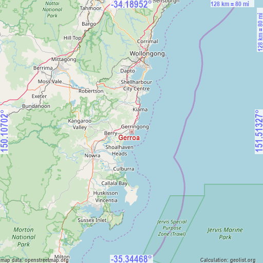
Gerroa GPS coordinates[2]
34° 46' 8.832" South, 150° 48' 36.504" East
| Map corner | latitude | longitude |
|---|---|---|
| Upper-left | -34.18952°, | 150.10702° |
| Center: | -34.76912°, | 150.81014° |
| Lower-right: | -35.34468°, | 151.51327° |
| Map W x H: | 128.4×128.4 km | = 79.8×79.8mi |
| max Lat: | -10.58257° ⇑65.4% North |
| Gerroa: | -34.76912° |
| min Lat: | ⇓34.6% South -43.31423° |
| min Long | Gerroa | max Long |
| 113.53327° | 150.81014° | 153.61246° |
| W 62.7%⇐ | ⇒37.3% E |
Elevation
Elevation of Gerroa is 21 m = 69 ft, and this is 101 m = 331 ft below average elevation for this country.
| Max E: |
1715 m = 5627 ft | 72.3% |
| Avg. | 122 m = 400 ft | |
| Gerroa | 21 m = 69 ft | |
Min E: |
-2 m = -7 ft | 27.7% |
See also: Australia elevation on elevation.city.
Geographical zone
Gerroa is located in South temperate zone (between Tropic of Capricorn and the Antarctic Circle). Distance of this Southern Tropic circle is 1260 km =782.9 mi to North.| Distance of | km | miles | from Gerroa |
|---|---|---|---|
| Equator | 3866 | 2402.2 | to North |
| Tropic Capricorn | 1260 | 782.9 | to North |
| Antarctic Circle | 3535.2 | 2196.7 | to South |
| South Pole | 6141.1 | 3815.9 | to South |


Nearby cities:
15 places around Gerroa: (largest is in red/bold)
• Berry
10.6 km =6.6 mi,  266°
266°
• Bomaderry
20.3 km =12.6 mi,  243°
243°
• Culburra Beach
18.3 km =11.4 mi,  195°
195°
• Flinders
21.1 km =13.1 mi,  11°
11°
• Gerringong
3 km =1.9 mi,  33°
33°
• Greenwell Point
17 km =10.6 mi,  205°
205°
• Jamberoo
13.9 km =8.6 mi,  346°
346°
• Kiama
11.9 km =7.4 mi,  18°
18°
• Kiama Downs
15.6 km =9.7 mi, 15°
• Kiama Heights
7.8 km =4.8 mi, 19°
• Minnamurra
16.7 km =10.4 mi, 12°
• Orient Point
16.5 km =10.3 mi, 199°
• Shell Cove
20.5 km =12.7 mi, 13°
• Shoalhaven Heads
10.9 km =6.8 mi, 213°
• Werri Beach
4.1 km =2.5 mi, 27°
Sources, notices
• [Note1] Compared only with cities in Australia existing in our database
• [Src1] Map data: © OpenStreetMap contributors (CC-BY-SA)
• [Src2] Other city data from geonames.org with taken over terms of usage.
• [Src3] Geographical zone / Annual Mean Temperature by Robert A. Rohde @ Wikipedia
