Berry geodata
Berry (New South Wales) is a populated place; located in Australia in Australia/Sydney (GMT+11) time zone. With population of 2,648 people, there are 2471 cities with bigger population in this country. Compared to other cities in Australia, 65.5% of cities are located further ↑North; 60.7% of cities are located further ←West and 79% of cities have higher elevation than Berry. Note1


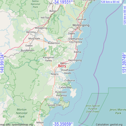
Berry GPS coordinates[2]
34° 46' 30.252" South, 150° 41' 39.696" East
| Map corner | latitude | longitude |
|---|---|---|
| Upper-left | -34.19551°, | 149.99124° |
| Center: | -34.77507°, | 150.69436° |
| Lower-right: | -35.35059°, | 151.39749° |
| Map W x H: | 128.4×128.4 km | = 79.8×79.8mi |
| max Lat: | -10.58257° ⇑65.5% North |
| Berry: | -34.77507° |
| min Lat: | ⇓34.5% South -43.31423° |
| min Long | Berry | max Long |
| 113.53327° | 150.69436° | 153.61246° |
| W 60.7%⇐ | ⇒39.3% E |
Elevation
Elevation of Berry is 16 m = 52 ft, and this is 106 m = 348 ft below average elevation for this country.
| Max E: |
1715 m = 5627 ft | 79% |
| Avg. | 122 m = 400 ft | |
| Berry | 16 m = 52 ft | |
Min E: |
-2 m = -7 ft | 21% |
See also: Australia elevation on elevation.city.
Geographical zone
Berry is located in South temperate zone (between Tropic of Capricorn and the Antarctic Circle). Distance of this Southern Tropic circle is 1260.7 km =783.4 mi to North.| Distance of | km | miles | from Berry |
|---|---|---|---|
| Equator | 3866.6 | 2402.6 | to North |
| Tropic Capricorn | 1260.7 | 783.4 | to North |
| Antarctic Circle | 3534.5 | 2196.2 | to South |
| South Pole | 6140.4 | 3815.5 | to South |


Nearby cities:
15 places around Berry: (largest is in red/bold)
• Bomaderry
11.3 km =7 mi,  222°
222°
• Cambewarra Village
13.4 km =8.3 mi,  246°
246°
• Gerringong
12.6 km =7.8 mi,  75°
75°
• Gerroa
10.6 km =6.6 mi,  86°
86°
• Greenwell Point
15.1 km =9.4 mi,  167°
167°
• Jamberoo
16 km =9.9 mi,  27°
27°
• Kangaroo Valley
15 km =9.3 mi,  285°
285°
• Kiama Heights
15.4 km =9.6 mi,  58°
58°
• North Nowra
14.3 km =8.9 mi,  229°
229°
• Nowra
14.9 km =9.3 mi, 215°
• Orient Point
15.7 km =9.8 mi,  161°
161°
• Shoalhaven Heads
9.6 km =6 mi,  151°
151°
• Tapitallee
15.4 km =9.6 mi, 246°
• Werri Beach
13.2 km =8.2 mi,  71°
71°
• Worrigee
15 km =9.3 mi,  201°
201°
Sources, notices
• [Note1] Compared only with cities in Australia existing in our database
• [Src1] Map data: © OpenStreetMap contributors (CC-BY-SA)
• [Src2] Other city data from geonames.org with taken over terms of usage.
• [Src3] Geographical zone / Annual Mean Temperature by Robert A. Rohde @ Wikipedia
