Cooran geodata
Cooran (Queensland) is a section of populated place; located in Australia in Australia/Brisbane (GMT+10) time zone. With population of 1,603 people, there are 3189 cities with bigger population in this country. Compared to other cities in Australia, 88.1% of cities are located further ↓South; 87.3% of cities are located further ←West and 69.8% of cities have lower elevation than Cooran. Note1


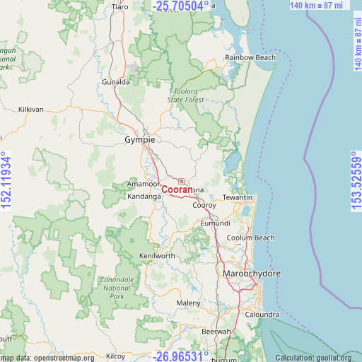
Cooran GPS coordinates[2]
26° 20' 12.804" South, 152° 49' 20.856" East
| Map corner | latitude | longitude |
|---|---|---|
| Upper-left | -25.70504°, | 152.11934° |
| Center: | -26.33689°, | 152.82246° |
| Lower-right: | -26.96531°, | 153.52559° |
| Map W x H: | 140.1×140.1 km | = 87.1×87.1mi |
| max Lat: | -10.58257° ⇑11.9% North |
| Cooran: | -26.33689° |
| min Lat: | ⇓88.1% South -43.31423° |
| min Long | Cooran | max Long |
| 113.53327° | 152.82246° | 153.61246° |
| W 87.3%⇐ | ⇒12.7% E |
Elevation
Elevation of Cooran is 102 m = 335 ft, and this is 20 m = 66 ft below average elevation for this country.
| Max E: |
1715 m = 5627 ft | 30.2% |
| Avg. | 122 m = 400 ft | |
| Cooran | 102 m = 335 ft | |
Min E: |
-2 m = -7 ft | 69.8% |
See also: Australia elevation on elevation.city.
Geographical zone
Cooran is located in South temperate zone (between Tropic of Capricorn and the Antarctic Circle). Distance of this Southern Tropic circle is 322.5 km =200.4 mi to North.| Distance of | km | miles | from Cooran |
|---|---|---|---|
| Equator | 2928.4 | 1819.6 | to North |
| Tropic Capricorn | 322.5 | 200.4 | to North |
| Antarctic Circle | 4472.8 | 2779.3 | to South |
| South Pole | 7078.7 | 4398.5 | to South |


Nearby cities:
15 places around Cooran: (largest is in red/bold)
• Amamoor
14.3 km =8.9 mi,  264°
264°
• Belli Park
19.1 km =11.9 mi,  180°
180°
• Black Mountain
8.7 km =5.4 mi,  142°
142°
• Cooroibah
16.6 km =10.3 mi,  100°
100°
• Cooroy
12.6 km =7.8 mi, 135°
• Cootharaba
16.4 km =10.2 mi,  61°
61°
• East Deep Creek
18.7 km =11.6 mi,  325°
325°
• Eerwah Vale
18.1 km =11.2 mi,  150°
150°
• Kandanga
15.8 km =9.8 mi,  246°
246°
• Kin Kin
9.2 km =5.7 mi,  36°
36°
• Lake Macdonald
12.2 km =7.6 mi,  116°
116°
• Mothar Mountain
10.8 km =6.7 mi, 333°
• Pomona
4.7 km =2.9 mi, 135°
• The Dawn
17.8 km =11.1 mi,  306°
306°
• Tinbeerwah
17.6 km =10.9 mi, 115°
Sources, notices
• [Note1] Compared only with cities in Australia existing in our database
• [Src1] Map data: © OpenStreetMap contributors (CC-BY-SA)
• [Src2] Other city data from geonames.org with taken over terms of usage.
• [Src3] Geographical zone / Annual Mean Temperature by Robert A. Rohde @ Wikipedia
