Belli Park geodata
Belli Park (Queensland) is a section of populated place; located in Australia in Australia/Brisbane (GMT+10) time zone. With population of 649 people, there are 4444 cities with bigger population in this country. Compared to other cities in Australia, 87.6% of cities are located further ↓South; 87.3% of cities are located further ←West and 68.2% of cities have lower elevation than Belli Park. Note1


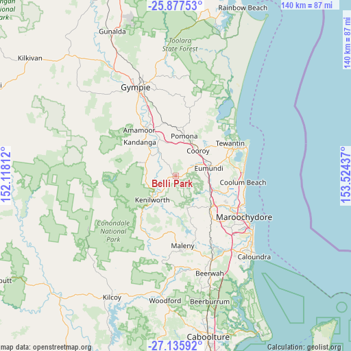
Belli Park GPS coordinates[2]
26° 30' 30.42" South, 152° 49' 16.464" East
| Map corner | latitude | longitude |
|---|---|---|
| Upper-left | -25.87753°, | 152.11812° |
| Center: | -26.50845°, | 152.82124° |
| Lower-right: | -27.13592°, | 153.52437° |
| Map W x H: | 139.9×139.9 km | = 86.9×86.9mi |
| max Lat: | -10.58257° ⇑12.4% North |
| Belli Park: | -26.50845° |
| min Lat: | ⇓87.6% South -43.31423° |
| min Long | Belli Park | max Long |
| 113.53327° | 152.82124° | 153.61246° |
| W 87.3%⇐ | ⇒12.7% E |
Elevation
Elevation of Belli Park is 93 m = 305 ft, and this is 29 m = 95 ft below average elevation for this country.
| Max E: |
1715 m = 5627 ft | 31.8% |
| Avg. | 122 m = 400 ft | |
| Belli Park | 93 m = 305 ft | |
Min E: |
-2 m = -7 ft | 68.2% |
See also: Australia elevation on elevation.city.
Geographical zone
Belli Park is located in South temperate zone (between Tropic of Capricorn and the Antarctic Circle). Distance of this Southern Tropic circle is 341.5 km =212.2 mi to North.| Distance of | km | miles | from Belli Park |
|---|---|---|---|
| Equator | 2947.5 | 1831.5 | to North |
| Tropic Capricorn | 341.5 | 212.2 | to North |
| Antarctic Circle | 4453.7 | 2767.4 | to South |
| South Pole | 7059.6 | 4386.6 | to South |


Nearby cities:
15 places around Belli Park: (largest is in red/bold)
• Black Mountain
13.3 km =8.3 mi,  23°
23°
• Cooroy
13.5 km =8.4 mi,  41°
41°
• Dulong
16.3 km =10.1 mi,  148°
148°
• Eerwah Vale
9.5 km =5.9 mi,  70°
70°
• Eumundi
13.4 km =8.3 mi,  75°
75°
• Flaxton
17.1 km =10.6 mi,  165°
165°
• Imbil
15.2 km =9.4 mi,  290°
290°
• Kenilworth
13.5 km =8.4 mi,  223°
223°
• Kureelpa
12.9 km =8 mi, 147°
• Lake Macdonald
17.6 km =10.9 mi, 38°
• Mapleton
13.7 km =8.5 mi,  160°
160°
• Ninderry
15.7 km =9.8 mi,  103°
103°
• North Arm
13.5 km =8.4 mi, 97°
• Pomona
16.1 km =10 mi,  12°
12°
• Yandina
14.6 km =9.1 mi,  113°
113°
Sources, notices
• [Note1] Compared only with cities in Australia existing in our database
• [Src1] Map data: © OpenStreetMap contributors (CC-BY-SA)
• [Src2] Other city data from geonames.org with taken over terms of usage.
• [Src3] Geographical zone / Annual Mean Temperature by Robert A. Rohde @ Wikipedia
